
Strings in Surpac play a foundational role in representing and analyzing three-dimensional spatial data. They are essential for modeling, surveying, and engineering tasks within the software. Below, we dive deep into the topic, covering all aspects of strings in Surpac.
What is Strings in Surpac?
A string in Surpac is a series of three-dimensional coordinates representing physical features. Just as lines and shapes define objects in a sketch, strings delineate essential aspects of geological and engineering models. For example, strings can represent the crest and toe of a mine bench, geological boundaries, road edges, and more.
Classification of Strings In Surpac
Strings in Surpac are classified into three primary types:
- Open Strings:
These are unclosed lines, either straight or curved. If multiple open strings share the same string number, they are divided into “open segments” and assigned segment numbers.
Example: Lines outlining a section of a road. - Closed Strings:
These form closed loops, such as circles or polygons, where the first and last coordinates are identical. Multiple closed strings sharing the same number are categorized as “closed segments.”
Example: Contour lines of a specific elevation on a topographic map. - Spot Height Strings:
These are sets of random points with no discernible feature or order. They are commonly used for elevation data or borehole coordinates.
Example: Elevation points scattered across a surface.
String Numbering and Purpose
Each string is assigned a unique string number ranging from 1 to 32,000. These numbers can either:
- Serve as identifiers with no inherent significance (e.g., in surveying), or
- Encode the purpose of the string (e.g., identifying a boundary string or geological feature).
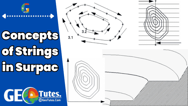
Understanding String Directions in Surpac
- The order of points in a string determines its direction:
- Clockwise Closed Strings: Represent positive (inclusive) areas.
- Anticlockwise Closed Strings: Represent negative (exclusive) areas.
- Nested closed strings (e.g., a clockwise string containing an anticlockwise string) define the area between them.
- Example:
- Area 1 (Clockwise): +300
- Area 2 (Anticlockwise): -100
- Total Area: 300 – 100 = 200
- Example:
Description Fields in Strings
Each point in a string can have associated descriptive data, referred to as point descriptions. These are typically attributes or metadata related to the feature. For example:
- A survey station’s name.
- Attributes such as water sample concentration and salinity.
Descriptions can be divided into up to 100 sub-fields (D1 to D100), separated by commas.
Example:Description = "TREE, 1.54, HOUSE"
- D1 = TREE
- D2 = 1.54
- D3 = HOUSE
The total description field length must not exceed 512 characters.
String File Formats
Strings are stored in string files (with .str extension), which are plain-text ASCII files containing structured data. Each string file comprises:
- Header Record: General file details like the date and purpose.
- Axis Record: Defines a 3D axis used for sectional analysis.
- String Records: Coordinates and descriptions of the points making up the strings.
Each string file can contain up to 32,000 different strings.
String Data Ranges and Numbers
- String Numbers: Identify and group strings, ranging from 1 to 32,000.
- Data Ranges: Can denote specific features or categories, such as contours, boreholes, or geological zones.
Naming Conventions for String Files
String files follow a two-part naming system:
- Location Code: A short identifier indicating the file’s content (e.g.,
SALfor salinity data). - ID Number: A numeric identifier, often indicating a sequence or timestamp.
Example:
SAL9001(Location: SAL, Year/Month: 1990/01)
Units of Measurement
- Surpac treats all data as unitless to ensure consistency within a project.
- Users must ensure all measurements are in compatible units, whether in metric (meters, ppm) or imperial (feet, ounces).
- Plotting Module Exception: When entering scale, units depend on whether metric or imperial settings are used.
- Metric: A scale of 1000 means 1mm = 1m.
- Imperial: A scale of 200 means 1 inch = 200 feet.
- Angles can be specified in degrees or grads (centesimal), with formats like
DDD.MMSSorDDD.DDDDfor decimal degrees.
String Types in Practice
- Survey Applications: Often use open strings for features like pit boundaries.
- Engineering and Geological Applications: Focus on closed strings for defining volumes, areas, and bench crests/toes.
File Extensions Related to Strings in surpac
- .str: Stores string data.
- .obs: Contains raw observations or imported external data.
String Directions and Volume Calculation
- Closed string directionality is critical for area and volume calculations.
- By convention:
- Clockwise: Positive area.
- Anticlockwise: Negative area.
Visualization:
Typical configurations:
- Y (Northing), X (Easting), Z (Elevation).
Applications of Strings in Modeling
Strings are vital in creating models like:
- Open pits: Strings represent mid-bench contours.
- Geological zones: Boundaries are defined with strings.
These models can be intersected using Surpac tools to analyze relationships between different datasets (e.g., aquifer zones within a pit).
Key Takeaways
Strings in Surpac offer a versatile and powerful way to represent and analyze spatial data, from simple survey lines to complex geological models.