
Introduction: What is a Range in Surpac?
In GEOVIA Surpac, a “range” is a way to define and control the display of specific data within a dataset, such as strings, segments, solids, and surfaces. It allows users to focus on particular subsets of data, simplifying tasks like visualization, analysis, and editing. Ranges act as filters that help users streamline their workflows when dealing with large or complex data files.
The Importance of Ranges in Surpac
The range in Surpac is essential for mining and geological modeling because it allows for efficient management of vast amounts of data. By defining a range, you can isolate specific features, structures, or areas within a dataset. For example:
- String numbers can represent different physical zones or features.
- Object numbers or trisolations can define parts of a solid or surface.
Understanding Range Syntax in Surpac
The syntax used for ranges in Surpac is straightforward and highly flexible. It allows for various combinations of data selection, including continuous sequences, incremental values, and even irregularly spaced numbers.
Here’s a breakdown of the commonly used syntax:
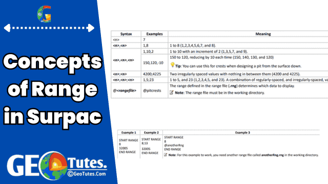
- Single Number:
7- Displays only the data associated with number 7.
- Continuous Range:
1,8- Displays all numbers from 1 to 8, i.e., 1, 2, 3, …, 8.
- Incremental Range:
1,10,2- Displays numbers from 1 to 10 with an increment of 2, i.e., 1, 3, 5, …, 9.
- Decreasing Range:
150,120,-10- Displays numbers from 150 down to 120, decrementing by 10, i.e., 150, 140, 130, …, 120.
- Irregular Values:
4200;4225- Displays specific values (4200 and 4225) without anything in between.
- Combination of Ranges:
1,5;23- Displays numbers 1 to 5 and 23, i.e., 1, 2, 3, 4, 5, 23.
- Using Range Files:
@<rangefile>- Loads predefined ranges from a file, e.g.,
@pitcrests.
- Loads predefined ranges from a file, e.g.,
Range Files in Surpac
To save time and avoid repeated typing, Surpac allows users to store ranges in range files with a .rng extension. These files follow a simple format:
- Begin with
START RANGE. - End with
END RANGE. - Include range values between these markers.
Applications of Range in Surpac
- Visualization: Display specific subsets of data, such as selected string numbers or specific surfaces.
- Editing: Focus on particular data points for targeted modifications.
- Analysis: Analyze specific zones or features without cluttering the workspace.
- Modeling: Use ranges to define regions for solid or surface modeling.
Tips and Best Practices for Working with Ranges in Surpac
- Plan Your Ranges: Before starting a project, plan which ranges will be needed for efficient organization and analysis.
- Keep Range Files Handy: Save commonly used ranges in
.rngfiles for quick access. - Combine Ranges: Use combinations of regularly spaced and irregularly spaced values for flexibility.
- Stay Within Character Limits: Range fields have a limit of 128 characters, so for complex ranges, use range files without character limits.
Advanced Use Cases of Ranges
- Crest Design in Mining: Use decreasing ranges (e.g.,
150,120,-10) to model pit crests effectively. - Complex Geometries: Combine multiple range types to handle intricate geological structures.
- Automation: Incorporate ranges into scripts for automated tasks, keeping in mind the 128-character limit in scripts.
Conclusion: The Power of Ranges in Surpac
The range in Surpac is a powerful feature that enables users to manage and manipulate data efficiently. By mastering range syntax and leveraging range files, users can enhance productivity and ensure more organized and streamlined workflows. Whether you are a geologist, engineer, or data analyst, understanding ranges is fundamental to unlocking Surpac’s full potential.