Tag: geotutes

  • Comprehensive Quiz on Planes in Surpac: Test Your Knowledge Here

    Comprehensive Quiz on Planes in Surpac: Test Your Knowledge Here

    Are you ready to test your understanding of planes in Surpac? This comprehensive quiz on planes in Surpac includes MCQs, true/false, fill-in-the-blanks, and short-answer questions to help you master the concept. Whether you’re a beginner or an advanced user, this engaging set of questions is tailored to boost your knowledge and enhance your Surpac skills. Dive in and challenge yourself today..

    Basic Questions

    1. What are planes in Surpac primarily used for?
      a) Data storage
      b) Displaying specific spatial data
      c) Data rotation
      d) Modifying software interfaceAnswer: b) Displaying specific spatial data
    2. What is the term used for the plane that is currently active in Surpac?
      a) Static plane
      b) Dynamic plane
      c) Projection plane
      d) Group planeAnswer: b) Dynamic plane
    3. What are the components of a plane corridor’s width in Surpac?
      a) Horizontal distance and vertical distance
      b) Towards and away projection distances
      c) Inclined and vertical distances
      d) Active and inactive distancesAnswer: b) Towards and away projection distances

    Intermediate Quiz on Planes in Surpac

    1. Which mode in Surpac allows users to zoom, pan, and rotate data?
      a) 2D Mode
      b) Projection Mode
      c) 3D Mode
      d) Graphics ModeAnswer: c) 3D Mode
    2. In Surpac, what happens to data outside the defined projection distances of the active plane?
      a) It is highlighted.
      b) It is hidden.
      c) It is deleted.
      d) It is merged with active data.Answer: b) It is hidden.
    3. Where can users find the active plane’s details in the Surpac interface?
      a) Tool panel
      b) Planes panel and Status bar
      c) Projection panel
      d) Graphics menuAnswer: b) Planes panel and Status bar

    Advanced Quiz on Planes in Surpac

    1. What is the difference between temporary and permanent storage of planes in Surpac?
      Answer: Temporary storage removes planes when Surpac is closed, while permanent storage saves them for future use.
    2. Name three orientations of planes that can be defined in Surpac.
      Answer: Horizontal, Vertical, Inclined.
    3. What is the purpose of plane groups in Surpac?
      Answer: Plane groups allow users to organize and manage multiple parallel planes, storing them in folders for collective or individual use.
    4. Explain how the projection distance is calculated in a plane corridor.
      Answer: The total projection distance is the sum of the “towards” distance and the “away” distance, determining the thickness of the corridor.

    Quiz on Planes in Surpac Questions (Continued)


    Multiple Choice Questions (MCQs)

    1. What is the default elevation of the active horizontal plane in Surpac when no plane is selected?
      a) 1000 meters
      b) 0 meters
      c) 5000 meters
      d) 10,000 metersAnswer: b) 0 meters
    2. Which professionals typically use planes to view vertical cross-sections of drillholes?
      a) Surveyors
      b) Engineers
      c) Geologists
      d) DesignersAnswer: c) Geologists
    3. What does 2D mode in Surpac restrict users from doing?
      a) Zooming in or out
      b) Panning
      c) Rotating data
      d) Selecting dataAnswer: c) Rotating data

    True/False Quiz on Planes in Surpac

    1. Planes in Surpac are stored permanently by default.
      Answer: False
    2. The projection distance determines the total thickness of a plane’s corridor.
      Answer: True
    3. Inclined planes in Surpac are only used for geological studies.
      Answer: False
    4. In 3D mode, users can rotate, zoom, and pan data freely.
      Answer: True

    Fill in the Blanks

    1. The _______ plane in Surpac determines the data currently visible in the Graphics view.
      Answer: Active
    2. A plane’s corridor width is equal to the _______ distance plus the _______ distance.
      Answer: Towards; Away
    3. In the Surpac interface, the _______ panel is used to manage and view planes.
      Answer: Planes
    4. _______ storage of planes allows users to save their settings for future use.
      Answer: Permanent

    Short Answer Questions

    1. Define projection distances in the context of planes in Surpac.
      Answer: Projection distances define the thickness of a plane’s corridor, consisting of “towards” and “away” distances. Together, these determine the data visible within the active plane.
    2. What is the function of the Planes Panel in Surpac?
      Answer: The Planes Panel allows users to view, activate, and manage planes, including checking properties and projection distances.
    3. Name two tasks for which engineers use planes in Surpac.
      Answer: Engineers use planes to view horizontal sections of block models and to design pits.
    4. What happens to temporarily stored planes when Surpac is closed?
      Answer: Temporarily stored planes are removed when Surpac is closed.
    5. How does the dynamic plane differ from other planes in Surpac?
      Answer: A dynamic plane is the default active plane without a specific name, automatically set for data interaction when no other plane is selected.

    Advanced Level Multiple Choice Quiz on Planes in Surpac (MCQs)

    1. What does the term “Dynamic Plane” refer to in Surpac?
      a) A stored plane used for projection
      b) A plane that is always active by default when unnamed
      c) A plane created for inclined data only
      d) A plane with no projection distancesAnswer: b) A plane that is always active by default when unnamed
    2. How can users access the properties of a specific plane in Surpac?
      a) From the Graphics window directly
      b) By right-clicking the plane type in the Planes Panel
      c) By selecting the projection distances tab
      d) Through the default toolbarAnswer: b) By right-clicking the plane type in the Planes Panel
    3. What folder types can planes be saved to in Surpac?
      a) Projection and Graphics folders
      b) Horizontal and Viewing folders
      c) Plan, Vertical, and Inclined folders
      d) Corridor and Dynamic foldersAnswer: c) Plan, Vertical, and Inclined folders
    4. Which factor determines whether a projection distance is “towards” or “away” from the view plane?
      a) Elevation of the active plane
      b) Orientation of the plane
      c) Total width of the corridor
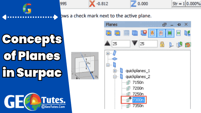
      d) Viewing mode selectedAnswer: b) Orientation of the plane
    5. What is indicated by a check mark next to a plane in the Planes Panel?
      a) The plane is being edited.
      b) The plane is temporarily stored.
      c) The plane is active.
      d) The plane has hidden data.Answer: c) The plane is active.
    6. In Surpac, how is the total thickness of a plane corridor calculated?
      a) Adding horizontal and vertical distances
      b) Multiplying the “towards” and “away” distances
      c) Adding the “towards” and “away” distances
      d) Subtracting “away” distance from “towards” distanceAnswer: c) Adding the “towards” and “away” distances
    7. What happens when a user selects a different plane in the Planes Panel?
      a) The previous plane’s data is deleted.
      b) The data within the new plane’s corridor becomes visible.
      c) All stored planes are reset to default.
      d) Data in all planes is merged for analysis.Answer: b) The data within the new plane’s corridor becomes visible.
    8. What is the purpose of viewing data in 2D mode in Surpac?
      a) To view multiple planes simultaneously
      b) To lock data to the active plane for zooming and panning
      c) To enable free rotation of data
      d) To combine multiple projection distances into one viewAnswer: b) To lock data to the active plane for zooming and panning
    9. What information is displayed in the Surpac Status Bar regarding planes?
      a) The group name of all stored planes
      b) The name and status of the active plane
      c) Projection distances for each plane
      d) The saved folder location of planesAnswer: b) The name and status of the active plane
    10. What is the purpose of the Parameter Set Editor in managing planes?
      a) To delete inactive planes
      b) To edit properties of a single plane in a group
      c) To combine plane data into one folder
      d) To view projection distances for all active planesAnswer: b) To edit properties of a single plane in a group
    11. Why are projection distances important for planes in Surpac?
      a) They determine the total elevation of the corridor.
      b) They define the visible data within the plane’s corridor.
      c) They restrict data to horizontal layers only.
      d) They increase storage space for plane files.Answer: b) They define the visible data within the plane’s corridor.
    12. What functionality is lost in 2D mode compared to 3D mode in Surpac?
      a) Viewing projection distances
      b) Activating planes
      c) Rotating the data
      d) Adjusting corridor thicknessAnswer: c) Rotating the data
    1. What happens if a plane is stored temporarily in Surpac?
      a) It becomes inaccessible until reactivated.
      b) It is automatically saved when Surpac is closed.
      c) It is removed after the session ends.
      d) It is saved with reduced projection distances.Answer: c) It is removed after the session ends.
    2. What does the grid in 2D mode represent?
      a) The elevation of the active plane
      b) The boundaries of all projection distances
      c) A combination of all active planes
      d) The intersection of multiple planesAnswer: a) The elevation of the active plane
    3. Which aspect can be modified through plane properties in Surpac?
      a) The thickness of the Graphics interface
      b) The projection distances of each plane
      c) The file type of stored planes
      d) The default 3D settingsAnswer: b) The projection distances of each plane
    4. What must users ensure when naming a plane group in Surpac?
      a) The name uses only numbers.
      b) The name contains unique special characters.
      c) The directory path is under 256 characters.
      d) The group is saved in the default folder.Answer: c) The directory path is under 256 characters.
    5. What determines the “away” projection distance in Surpac?
      a) The corridor’s total width
      b) The active plane’s orientation
      c) The graphics view setting
      d) The elevation of the planeAnswer: b) The active plane’s orientation
    6. How can users identify the active plane in the Planes Panel?
      a) By its color in the Graphics window
      b) By a highlighted icon in the toolbar
      c) By a check mark next to the plane’s name
      d) By its unique projection distanceAnswer: c) By a check mark next to the plane’s name
    7. What key role does grouping planes serve in Surpac?
      a) It merges all stored planes into one file.
      b) It organizes parallel planes for efficient management.
      c) It locks inactive planes from editing.
      d) It reduces the corridor width of all planes.Answer: b) It organizes parallel planes for efficient management.
    8. What happens to data outside the projection distances of a plane in 3D mode?
      a) It remains visible but dimmed.
      b) It is permanently deleted.
      c) It is hidden from view.
      d) It is stored temporarily for later use.Answer: c) It is hidden from view.
    9. Which folder type is not used for saving planes in Surpac?
      a) Plan folder
      b) Inclined folder
      c) Dynamic folder
      d) Vertical folderAnswer: c) Dynamic folder
    10. What must be done to access the properties of a plane group in Surpac?
      a) Use the Parameter Set Editor.
      b) Open the main Graphics window.
      c) Adjust settings in the Status Bar.
      d) Activate all stored planes.Answer: a) Use the Parameter Set Editor.

    These advanced-level questions challenge a deeper understanding of the Planes in Surpac concept.

  • Exploring the Concepts of Planes in Surpac

    Exploring the Concepts of Planes in Surpac

    Planes in Surpac are fundamental tools for visualizing and analyzing spatial data. In this detailed article, we’ll break down their role, functionality, and significance in mining and geology while maintaining simplicity for easy understanding. By the end of this guide, you’ll have a comprehensive grasp of planes in Surpac and their various applications.


    What Are Planes in Surpac?

    In Surpac, planes are defined as “corridors” within a three-dimensional space that help in data visualization. These corridors are established by defining a flat plane (horizontal, vertical, or inclined) and specifying distances toward and away from the plane. The total width of the corridor is the sum of these distances.

    When a plane is active, only data within this corridor is displayed, making it easier to focus on specific sections while hiding irrelevant data.


    Why Are Planes Important?

    Planes serve diverse purposes for geologists, engineers, and surveyors:

    • Geologists use them for examining vertical cross-sections of drillholes and surface topography.
    • Engineers utilize planes to view horizontal sections of block models, especially during pit design.
    • Surveyors create cross-sections of mined areas to analyze cuts over specified periods.

    Understanding the “Active Plane”

    The active plane is the current reference plane in Surpac. It determines where data is projected in the Graphics view. Here’s how it works:

    • If no plane is chosen, a default horizontal plane at zero elevation with a 10,000-meter projection distance (above and below) becomes active.
    • Data outside the defined corridor is hidden from view, making it easier to work within specific zones.
    • The location of digitized points aligns with the intersection of the active plane and where you click in the Graphics view.

    To identify the active plane, users can check the Status Bar or the Planes Panel.


    Types of Planes in Surpac

    1. Horizontal Planes
      Useful for analyzing block models or viewing flat topographic surfaces.
    2. Vertical Planes
      Commonly employed in geological studies to inspect drillhole cross-sections.
    3. Inclined Planes
      Designed for scenarios where neither horizontal nor vertical planes fit, such as analyzing inclined ore bodies.

    Key Features of Planes in Surpac

    1. Planes Panel

    The Planes Panel in Surpac is a user interface element that helps manage plane settings. By default, it is located in the upper-right corner of the Graphics window and can be relocated for convenience.

    2. Projection Distances

    Projection distances define the thickness of a plane’s corridor. The total thickness is calculated as the sum of the “towards” and “away” projection distances. Users can adjust these settings to include or exclude specific data.

    3. Storage Options

    Planes can be stored either temporarily or permanently:

    • Temporary Storage: Planes are removed once Surpac is closed.
    • Permanent Storage: Stored planes are saved in files and remain available for future use.

    4. Groups of Planes

    Planes can be grouped into collections based on their orientation (horizontal, vertical, inclined). These groups can be managed and edited collectively or individually using the Parameter Set Editor.


    Viewing Modes for Planes in Surpac

    Surpac offers two viewing modes for data visualization:

    • 2D Mode: Projects all data onto the active plane, ideal for focused cross-sectional views. Users can zoom and pan but cannot rotate data in this mode.
    • 3D Mode: Provides a full three-dimensional view, allowing for rotation, zooming, and panning to explore data from different angles.

    Customizing and Managing Planes

    Accessing Plane Properties

    Users can view and edit the properties of individual or grouped planes. For instance:

    • Adjusting projection distances.
    • Renaming or relocating planes within folders.

    Dynamic Plane

    If an active plane lacks a name, it is termed the Dynamic Plane. This default setting ensures continuous interaction with data during visualization or digitization.


    Practical Applications of Planes in Surpac

    1. Mining Operations
      • Creating pit designs by viewing horizontal slices of a block model.
      • Analyzing ore distribution within specific layers.
    2. Geological Studies
      • Investigating subsurface structures using vertical and inclined cross-sections.
    3. Surveying
      • Visualizing mined areas and cut depths over time to monitor progress.

    Enhancing Workflows with Planes in Surpac

    By mastering the concepts of planes, users can achieve:

    • Better Data Management: Focusing on relevant data while hiding distractions.
    • Improved Analysis: Customizing projection distances to suit specific tasks.
    • Seamless Collaboration: Sharing stored planes among team members for consistent project outcomes.

    Final Thoughts on Planes in Surpac

    Planes in Surpac are essential for efficient data visualization and analysis in geological and mining applications. Whether you’re a geologist exploring drillhole data, an engineer designing a pit, or a surveyor monitoring mining cuts, understanding how to use planes can significantly enhance your workflow

  • Comprehensive 40+ Surpac Drafting Function Quiz Bank

    Comprehensive 40+ Surpac Drafting Function Quiz Bank

    Welcome to the ultimate Surpac Drafting Function Quiz Bank Or Questions and answers bank!. This comprehensive collection of questions and answers is designed to help you master the advanced features, tools, and applications of Surpac’s drafting mode. Whether you’re preparing for professional certifications, you want to improve your technical knowledge. Boost your drafting precision in geological and mining projects, this quiz bank offers valuable insights. Test your understanding of key concepts like snapping options, Edge Follow mode, active plane usage, and more. Dive in to sharpen your skills and excel in using Surpac Drafting Function effectively!

    Surpac Drafting Function Quiz Bank

    Multiple Choice Questions (MCQs):

    1. What does the Surpac Drafting mode primarily help with?
      a) Data analysis
      b) Precise digitizing on active planes
      c) Image rendering
      d) File management
      Answer: b) Precise digitizing on active planes
    2. Which key activates the Drafting mode in Surpac?
      a) F2
      b) CTRL
      c) 5
      d) Alt
      Answer: c) 5
    3. What does the “Angle Snap” option allow you to do?
      a) Define snapping distance intervals
      b) Set a snapping offset
      c) Align points to specific angular intervals
      d) Trace existing lines
      Answer: c) Align points to specific angular intervals
    4. Which mode in Surpac allows you to create a point that follows an existing line?
      a) Drafting Mode
      b) Tool Properties Mode
      c) Edge Follow Mode
      d) Status Bar Mode
      Answer: c) Edge Follow Mode
    5. What information is displayed in the status bar while digitizing?
      a) Color settings and grid details
      b) Distance, bearing, and dip
      c) Font size and alignment
      d) Coordinates and altitude
      Answer: b) Distance, bearing, and dip

    True/False Questions:

    1. Edge Follow mode works only in 2D planes.
      Answer: False
    2. Distance Snap ensures new points align with specific angular intervals.
      Answer: False
    3. The status bar shows real-time data when moving a point using the Move tool.
      Answer: True
    4. You can customize line colors and font size for the drafting function in the tool settings.
      Answer: True
    5. Offset Snap only works when Edge Follow mode is active.
      Answer: True

    Fill-in-the-Blank Questions:

    1. The Drafting function in Surpac allows precise digitizing at specific _______ or _______ from existing points or lines.
      Answer: distances, angles
    2. To start Edge Follow mode, hold _______ and click a line in Drafting mode.
      Answer: CTRL
    3. The tool properties pane allows setting _______ snap, _______ snap, and _______ snap for better control during drafting.
      Answer: angle, distance, offset
    4. Active planes in Surpac display angles and distances relevant to the _______ plane.
      Answer: active
    5. In the status bar, _______ is the vertical angle measured between a selected point and the existing line.
      Answer: dip

    Additional Multiple Choice Questions (MCQs)

    1. Which menu provides access to Drafting mode in Surpac?
      a) Create > Digitize > New Point
      b) Graphics > Tool Settings
      c) File > Open Drafting
      d) View > Draft Mode
      Answer: a) Create > Digitize > New Point
    2. What happens when you activate Edge Follow mode in a 3D plane?
      a) The offset distance measures from the selected plane’s intersection point.
      b) It creates parallel lines automatically.
      c) The mode gets disabled automatically.
      d) Points cannot be digitized in 3D.
      Answer: a) The offset distance measures from the selected plane’s intersection point.
    3. What is displayed when you use the Move tool to reposition a point?
      a) Only the new coordinates
      b) Distance and angle from the original point
      c) The file name and line weight
      d) The color and font of the moved point
      Answer: b) Distance and angle from the original point
    4. What settings can be adjusted in the Graphics > Tool Settings menu for Drafting mode?
      a) Axis scaling and grid spacing
      b) Font size, line colors, and reference lines
      c) Data formats and snapping presets
      d) Layer visibility and zoom levels
      Answer: b) Font size, line colors, and reference lines
    5. Which feature in Drafting mode is particularly useful for tracing existing shapes?
      a) Distance Snap
      b) Edge Follow Mode
      c) Move Tool
      d) Tool Properties Pane
      Answer: b) Edge Follow Mode
    6. In Edge Follow mode, what key must be held down to select a line?
      a) Alt
      b) CTRL
      c) Shift
      d) F5
      Answer: b) CTRL
    7. When drafting on a plane, how are the angles and distances calculated?
      a) Based on the horizontal grid only
      b) Relative to the active plane’s orientation
      c) Aligned to the global 3D axis
      d) Independent of the plane’s configuration
      Answer: b) Relative to the active plane’s orientation
    8. What happens if a line selected in Edge Follow mode is above or below the selected point?
      a) The dip value becomes non-zero.
      b) The angle snaps automatically to 0 degrees.
      c) The system generates an error.
      d) The snapping is disabled for the current action.
      Answer: a) The dip value becomes non-zero.
    9. Which snapping option in Drafting mode is effective only in Edge Follow mode?
      a) Angle Snap
      b) Distance Snap
      c) Offset Snap
      d) Height Snap
      Answer: c) Offset Snap
    10. What is the main benefit of using snapping options in Drafting mode?
      a) To reduce rendering time
      b) To ensure accuracy in digitizing
      c) To improve visual quality
      d) To automate point creation
      Answer: b) To ensure accuracy in digitizing
    1. What does the Offset Snap option control in Drafting mode?
      a) The snapping interval for angles
      b) The snapping interval for distances
      c) The distance between a new point and an existing line
      d) The alignment of points with the grid
      Answer: c) The distance between a new point and an existing line
    2. Which mode is most suitable for drafting on inclined planes in Surpac?
      a) Default Mode
      b) 2D Plane Mode
      c) 3D Plane Mode
      d) Grid Mode
      Answer: c) 3D Plane Mode
    3. In Drafting mode, what dictates the reference for angle measurements?
      a) Global axis
      b) Active plane’s orientation
      c) Grid alignment
      d) Default snapping settings
      Answer: b) Active plane’s orientation
    4. What is the purpose of the Tool Properties Pane in Drafting mode?
      a) To display coordinates of points
      b) To adjust snapping settings like angle and distance
      c) To visualize the drafted lines
      d) To set the resolution of the graphics display
      Answer: b) To adjust snapping settings like angle and distance
    5. What happens if a line in Edge Follow mode does not lie on the active plane?
      a) The point is placed at a random location.
      b) The offset distance is calculated from the intersection point.
      c) Edge Follow mode is disabled.
      d) The system highlights an error.
      Answer: b) The offset distance is calculated from the intersection point.
    6. Which snapping option ensures that newly digitized points align with fixed measurement intervals?
      a) Angle Snap
      b) Distance Snap
      c) Offset Snap
      d) Planar Snap
      Answer: b) Distance Snap
    7. What feedback does the Status Bar provide during drafting?
      a) Line thickness and point dimensions
      b) Real-time distance, bearing, and dip
      c) Active tool settings
      d) Current plane orientation
      Answer: b) Real-time distance, bearing, and dip
    8. How can the drafting settings be customized for user preferences?
      a) By editing the active layer properties
      b) Through Graphics > Tool Settings
      c) By accessing the File > Drafting menu
      d) Using the default snapping shortcuts
      Answer: b) Through Graphics > Tool Settings
    9. Which aspect of Drafting mode enhances visual clarity in the workspace?
      a) Font size and line color customization
      b) Snapping interval adjustments
      c) Automatic grid alignment
      d) 3D rendering options
      Answer: a) Font size and line color customization
    10. What is the recommended way to trace complex shapes in Drafting mode?
      a) Use Offset Snap exclusively
      b) Enable Edge Follow Mode
      c) Adjust the Default Settings for grids
      d) Rely on manual point placement
      Answer: b) Enable Edge Follow Mode
    11. What does the dip value represent in the Status Bar?
      a) The height of the selected point above sea level
      b) The vertical angle between a point and a line
      c) The angle relative to the global axis
      d) The slope of the active plane
      Answer: b) The vertical angle between a point and a line
    12. How does Drafting mode ensure alignment with horizontal or vertical references?
      a) By enabling Offset Snap
      b) Using predefined reference lines
      c) By switching to 3D planes
      d) Through automatic distance calculation
      Answer: b) Using predefined reference lines
    13. Which key feature makes Drafting mode highly accurate for geological applications?
      a) Real-time snapping feedback
      b) Automated model validation
      c) Integration with satellite imagery
      d) Layer-based drafting support
      Answer: a) Real-time snapping feedback
    14. What is the default method for activating Edge Follow mode?
      a) Select the line and press ALT
      b) Right-click the line and choose “Follow Edge”
      c) Hold CTRL and click the line
      d) Use the snapping tool with active grid
      Answer: c) Hold CTRL and click the line
    15. In Drafting mode, what determines the snapping interval for distance and angle?
      a) The active plane’s resolution
      b) User-defined values in the Tool Properties Pane
      c) Automatic system configuration
      d) Grid alignment settings
      Answer: b) User-defined values in the Tool Properties Pane
    1. What is the impact of using snapping options in a 3D plane that intersects multiple lines?
      a) The system ignores snapping and uses the nearest point.
      b) Snapping aligns points to the projection of the line on the active plane.
      c) Snapping is disabled automatically.
      d) The points are aligned to the global grid.
      Answer: b) Snapping aligns points to the projection of the line on the active plane.
    2. How does the Offset Snap option behave differently in 2D versus 3D planes?
      a) It calculates offsets only in 2D mode.
      b) It measures from the nearest vertex in 3D.
      c) It uses plane intersection points for calculations in 3D.
      d) It snaps only to horizontal planes.
      Answer: c) It uses plane intersection points for calculations in 3D.
    3. Which action in Drafting mode can lead to creating a point with a non-zero dip value?
      a) Selecting a vertical reference line
      b) Following a line that is not on the active plane
      c) Disabling snapping options
      d) Using an offset snap in 2D planes
      Answer: b) Following a line that is not on the active plane
    4. What setting must be adjusted to ensure the drafting lines are color-coded for different types of geological features?
      a) Tool Properties Pane settings
      b) Graphics > Tool Settings > Line Colors
      c) Active layer properties in the default menu
      d) 3D settings under rendering options
      Answer: b) Graphics > Tool Settings > Line Colors
    5. When digitizing on active planes, how can you ensure measurements are relative to a specific origin point?
      a) By enabling Edge Follow Mode
      b) By using snapping settings and setting a reference line
      c) By selecting the “Reset Origin” tool
      d) By customizing the distance snap value
      Answer: b) By using snapping settings and setting a reference line
    6. What advanced technique is used to digitize along curves in Drafting mode?
      a) Adjusting snapping intervals to dynamic values
      b) Activating Edge Follow Mode and holding SHIFT
      c) Using the Offset Snap with a small distance value
      d) Combining Edge Follow Mode with active snapping options
      Answer: d) Combining Edge Follow Mode with active snapping options
    7. How does the system calculate bearing values in Drafting mode when working on inclined planes?
      a) Based on the global axis and horizontal alignment
      b) Using the shortest distance to the nearest point
      c) Relative to the active plane’s reference angle
      d) As a projection on the vertical axis
      Answer: c) Relative to the active plane’s reference angle
    8. Which aspect of Drafting mode enhances its usability for modeling underground structures?
      a) Integration with real-time rendering tools
      b) 3D Edge Follow mode with accurate offset calculations
      c) Automatic grid alignment for vertical shafts
      d) Dynamic snapping based on geological layers
      Answer: b) 3D Edge Follow mode with accurate offset calculations
    9. What is the recommended way to adjust tool snapping for precision in highly detailed 3D models?
      a) Increase the default snapping intervals in Graphics settings
      b) Use finer snapping intervals for distance and angle
      c) Disable snapping entirely for manual control
      d) Align the snapping settings to the global grid spacing
      Answer: b) Use finer snapping intervals for distance and angle
    10. How can the Tool Properties Pane be used to achieve precision in geological fault mapping?
      a) By setting a fixed offset snap value for line spacing
      b) By activating real-time grid overlays
      c) By disabling Edge Follow mode for freeform mapping
      d) By aligning tool settings with vertical references only
      Answer: a) By setting a fixed offset snap value for line spacing
    11. What happens if you digitize a point outside the active plane in Drafting mode?
      a) The point is placed at the nearest grid intersection.
      b) The software projects the point onto the active plane.
      c) The action is invalid, and an error is displayed.
      d) The snapping is overridden by the global reference frame.
      Answer: b) The software projects the point onto the active plane.
    12. Which combination of settings would you use to model a complex geological fold accurately?
      a) Distance snap and Angle snap with default values
      b) Edge Follow mode with Offset Snap and fine snapping intervals
      c) Snapping disabled with manual point creation
      d) Only the default tool settings with Edge Follow disabled
      Answer: b) Edge Follow mode with Offset Snap and fine snapping intervals
    13. In what situation would you customize the reference line for angle measurements in Drafting mode?
      a) When working exclusively on horizontal grids
      b) To align the angle measurements with inclined geological strata
      c) For mapping features with irregular boundaries
      d) To ensure uniform snapping in vertical shafts
      Answer: b) To align the angle measurements with inclined geological strata
    14. What advanced feature can ensure proper alignment while digitizing multiple lines along a fault plane?
      a) Setting an offset snap with active Edge Follow mode
      b) Increasing font size for better visibility
      c) Using the default snapping configuration
      d) Disabling distance snapping for freeform inputs
      Answer: a) Setting an offset snap with active Edge Follow mode
    15. How can you validate the accuracy of a drafted model in Surpac Drafting mode?
      a) By comparing it to the grid settings
      b) Using the status bar to verify distances, bearings, and dips
      c) By toggling the reference lines dynamically
      d) Running a 3D rendering comparison
      Answer: b) Using the status bar to verify distances, bearings, and dips

    These advanced questions push users to think critically about the Surpac Drafting Function, requiring a deep understanding of its settings, applications, and implications in complex geological and mining scenarios.

  • Master Surpac Drafting Function: A Complete Guide

    Master Surpac Drafting Function: A Complete Guide

    Drafting plays a critical role in modern geological modeling and mine planning. GEOVIA Surpac’s drafting function is a precise and user-friendly feature tailored for professionals who need to digitize and edit points, lines, and planes with accuracy. This article will provide an in-depth exploration of the Surpac Drafting Function, covering its tools, features, and relevant concepts to enhance understanding and usability.


    What is the Drafting Function in Surpac?

    The drafting function in Surpac is a mode designed to enable users to digitize with precision at specific angles or distances from existing points, lines, or objects. It is a pivotal feature for geological mapping, ensuring accuracy in defining locations and measurements. Surpac allows drafting on active planes, supporting both 2D and 3D modeling.


    How to Start Drafting Mode in Surpac

    Getting started with drafting mode in Surpac is straightforward. You can initiate it using any of these methods:

    1. Keyboard Shortcut: Press the number key 5.
    2. Context Menu: Right-click in the graphics area and select “Drafting” from the menu.
    3. Toolbar Access: On the “Digitize” toolbar, click the mode button and select “Drafting.”

    Key Features of Surpac Drafting Function

    Tool Properties Pane

    Upon entering drafting mode, the tool properties pane appears, allowing users to set snapping options and customize their drafting experience:

    1. Angle Snap: Enables points to snap to a specific angular interval, such as 5 degrees.
    2. Distance Snap: Ensures new points align to defined distances, such as 10 units.
    3. Offset Snap: In edge-follow mode, this determines the distance between an existing line and the new point created.

    Edge Follow Mode

    The Edge Follow Mode allows users to trace existing lines seamlessly. This is particularly effective for 2D drafting but also functional in 3D when the planes align.

    • Usage: Activate by holding CTRL and clicking an existing line.
    • Benefit: Facilitates smooth alignment and spacing when drafting near or along edges.

    Status Bar Integration

    While digitizing, the status bar displays real-time data:

    • Distance: From the selected point to the cursor.
    • Bearing: The angular direction.
    • Dip: Indicates the vertical angle between the point and the line.

    Drafting on Planes: A Detailed Look

    Drafting in Surpac occurs on active planes, where angles and distances are contextual to the plane’s orientation. This approach ensures accuracy in representing spatial relationships in both two-dimensional and three-dimensional environments.

    • 2D Plane Mode: Ideal for horizontal mapping.
    • 3D Plane Mode: Useful for inclined or complex geological formations.

    Customizing Drafting Settings

    Surpac allows users to adjust drafting settings for enhanced functionality. These options are accessible through the “Graphics > Tool Settings” menu:

    • Font Size: Adjust the visibility of text for angle and distance indicators.
    • Line Colors: Customize colors for clarity and differentiation.
    • Reference Lines: Define angular measurements relative to horizontal or vertical planes.

    Practical Applications of the Drafting Function

    Geological Mapping

    Drafting facilitates the creation of accurate geological maps by enabling the precise placement of features and boundaries.

    Mine Planning

    In mine design, drafting is essential for defining tunnels, slopes, and benches with specific angles and distances.

    Surveying and Data Validation

    Surveyors use the drafting function to validate and align new data points with existing geological models.


    Benefits of Using Surpac Drafting Function

    • Precision: Ensures accurate placement of points and lines.
    • Efficiency: Reduces manual errors through snapping and predefined intervals.
    • Flexibility: Supports both 2D and 3D modeling environments.
    • Ease of Use: Intuitive interface with helpful tooltips and status bar feedback.

    Tips for Optimizing the Surpac Drafting Function

    1. Familiarize with Snapping Options: Adjust angle, distance, and offset snaps to suit your project needs.
    2. Use Edge Follow Mode for Curves: Ensure smooth tracing of complex shapes.
    3. Leverage Default Settings: Customize frequently used options like colors and fonts for a personalized experience.
    4. Utilize the Status Bar: Monitor real-time measurements to ensure alignment with project specifications.

    Conclusion

    The Surpac Drafting Function is an indispensable tool for professionals in geology and mine planning. Its advanced features, such as snapping intervals, edge-follow mode, and customizable settings, empower users to draft with unparalleled accuracy and efficiency. Whether you’re mapping geological formations or designing intricate mining layouts, mastering Surpac’s drafting capabilities will significantly enhance your workflow.

    Embrace the Surpac Drafting Function to achieve precision and efficiency in all your geological and mining endeavors

  • Comprehensive Questions and Answers Bank on Range in Surpac

    Comprehensive Questions and Answers Bank on Range in Surpac

    Welcome to the ultimate Questions and Answers Bank on Range in Surpac! This comprehensive guide is designed to enhance your understanding of the Range in Surpac, a vital feature in geological modeling and mining workflows. Whether you’re a beginner or an experienced user, these curated questions cover essential topics like range syntax, applications, range files, and best practices. Dive into this detailed Q&A to test your knowledge, strengthen your skills, and master how to effectively use ranges in Surpac. Perfect for learning, revision, and exam preparation!

    Quiz Questions on Range in Surpac

    Multiple-Choice Questions (MCQs):

    1. What is a “range” used for in Surpac?
      • A) To display a subset of data in a dataset.
      • B) To export data to a different format.
      • C) To perform calculations on a dataset.
      • D) To generate 3D models automatically.
        Answer: A
    2. What file extension is used for range files in Surpac?
      • A) .txt
      • B) .rng
      • C) .dat
      • D) .xml
        Answer: B
    3. Which syntax is correct for specifying a decreasing range?
      • A) 10,1,-1
      • B) 10,5,1
      • C) 10,1;5
      • D) 10;-1
        Answer: A
    4. What does the range syntax 1,10,2 mean?
      • A) Numbers from 1 to 10 incrementing by 2.
      • B) Numbers from 1 to 10 in descending order.
      • C) Irregularly spaced numbers including 1, 2, and 10.
      • D) All numbers between 1 and 10, excluding 2.
        Answer: A
    5. Which of the following can be included in a range file?
      • A) Irregular values only.
      • B) Regularly spaced values only.
      • C) Both regularly and irregularly spaced values.
      • D) Only decreasing ranges.
        Answer: C

    True/False Questions:

    1. A range field in Surpac accepts a maximum of 128 characters.
      Answer: True
    2. Range files allow hierarchical range definitions by referencing other range files.
      Answer: True
    3. The syntax 1;5;10 represents numbers 1 to 10 incremented by 5 in a range.
      Answer: False (This is irregularly spaced values).
    4. Range files can include comments to document the ranges.
      Answer: False (No comments are supported in the example provided).
    5. A range in Surpac is only applicable to string numbers.
      Answer: False (It can be used for strings, solids, surfaces, and other numerical data).

    Fill-in-the-Blank Questions:

    1. The first line in a range file must be __________.
      Answer: START RANGE
    2. To use a predefined range from another file, the syntax @__________ is used.
      Answer: <rangefile>
    3. A range file must end with the line __________.
      Answer: END RANGE
    4. The range syntax 150,120,-10 represents numbers starting at 150 and decreasing by ______ each time.
      Answer: 10
    5. Surpac range fields are commonly used in the ________ form for drawing or filtering data.
      Answer: DRAW NUMBERS

    These questions cover various aspects of the document, from basic definitions to specific examples of range syntax and applications.

    Additional Multiple-Choice Questions (MCQs)

    6. What does the range syntax 8;15 represent?

    • A) A continuous range from 8 to 15.
    • B) Irregular values 8 and 15 only.
    • C) Numbers from 8 to 15 with an increment of 2.
    • D) Decreasing numbers from 15 to 8.
      Answer: B

    7. Which of the following describes the function of range files?

    • A) They store 3D model definitions.
    • B) They save and reuse predefined ranges.
    • C) They export range data to external applications.
    • D) They validate range syntax.
      Answer: B

    8. What happens if a range file is not in the working directory?

    • A) It will generate an error.
    • B) The file will automatically be created.
    • C) Surpac will load a default range.
    • D) The range will be ignored.
      Answer: D

    9. What is the limit for characters in a Surpac range field?

    • A) 64
    • B) 128
    • C) 256
    • D) Unlimited
      Answer: B

    10. How can regularly and irregularly spaced values be combined in a range?

    • A) By separating them with a semicolon.
    • B) By listing them in different files.
    • C) By using the syntax @range.
    • D) By entering them in separate range fields.
      Answer: A

    11. In Surpac, the syntax @pitcrests refers to what?

    • A) A custom drawing command.
    • B) A predefined range in a range file.
    • C) A surface modeling function.
    • D) A range visualization tool.
      Answer: B

    12. Which range syntax would display numbers 1, 4, 7, and 10?

    • A) 1;4;7;10
    • B) 1,10,3
    • C) 1,10,2
    • D) 1,4,7,10
      Answer: B

    13. What is the first step to create a valid range file?

    • A) Add the keyword END RANGE.
    • B) Include a numerical range in the file.
    • C) Start with the line START RANGE.
    • D) Save the file with a .txt extension.
      Answer: C

    14. Which syntax would display all numbers from 5 to 15, excluding 10?

    • A) 5,10;15
    • B) 5,15,2
    • C) 5,9;11,15
    • D) 5;15
      Answer: C

    15. What is the purpose of using hierarchical definitions in range files?

    • A) To reduce the size of the file.
    • B) To include ranges from other files.
    • C) To create 3D models automatically.
    • D) To define ranges for multiple datasets simultaneously.
      Answer: B

    16. How are decremental ranges defined in Surpac?

    • A) By entering values manually.
    • B) Using negative increments in syntax.
    • C) Using the ; separator.
    • D) By referencing another range file.
      Answer: B

    17. Which of the following is a valid range file name?

    • A) rangefile.rng
    • B) range_data.txt
    • C) rangefile.xml
    • D) range.list
      Answer: A

    18. When combining ranges using the syntax 1,5;10, which values are included?

    • A) 1, 5, and 10 only.
    • B) 1 to 5 and 10.
    • C) 1 to 5, skipping 10.
    • D) All values between 1 and 10.
      Answer: B

    19. Which keyword must be added to mark the end of a range file?

    • A) CLOSE RANGE
    • B) STOP RANGE
    • C) END RANGE
    • D) FINAL RANGE
      Answer: C

    20. What is a key advantage of using range files?

    • A) They support unlimited character lengths for ranges.
    • B) They allow exporting of data directly to CAD software.
    • C) They automate 3D solid creation.
    • D) They simplify syntax limitations in scripts.
      Answer: A

    21. What does the syntax 2,20,3 represent in Surpac?

    • A) Numbers 2 to 20, incrementing by 3.
    • B) Numbers 2, 3, and 20 only.
    • C) Numbers 2 to 20, incrementing by 2.
    • D) Numbers 20 to 2, decrementing by 3.
      Answer: A

    22. What should you do if a range expression exceeds 128 characters?

    • A) Truncate the range expression.
    • B) Use multiple range fields.
    • C) Save it in a range file.
    • D) Reduce the range values.
      Answer: C

    23. Which of the following is NOT a valid use of ranges in Surpac?

    • A) Filtering specific string numbers.
    • B) Displaying segments of a solid.
    • C) Modifying coordinate systems.
    • D) Visualizing specific data subsets.
      Answer: C

    24. Which syntax is used to define a range that includes irregular values?

    • A) n;n;n
    • B) n;n
    • C) n;n;n,n
    • D) n;
      Answer: B

    25. In a hierarchical range definition, what does @anotherRng indicate?

    • A) A command to execute a script.
    • B) Reference to another range file.
    • C) A wildcard to include all ranges.
    • D) A new solid’s range.
      Answer: B

    26. What happens if you include @anotherRng in a range file but the referenced file is missing?

    • A) The process continues with a warning.
    • B) The system ignores the missing file.
    • C) The range expression fails.
    • D) It creates an empty range by default.
      Answer: C

    27. Which range syntax is appropriate for selecting numbers 50 to 100, decrementing by 10?

    • A) 50,100,-10
    • B) 100,50,-10
    • C) 50,-10,100
    • D) 50;100,-10
      Answer: B

    28. When combining range files, which syntax is used to include additional range definitions?

    • A) #
    • B) @
    • C) $
    • D) &
      Answer: B

    29. What is the maximum number of characters allowed for a range field in a TCL script?

    • A) 64
    • B) 128
    • C) 256
    • D) Unlimited
      Answer: B

    30. In Surpac, what is a common reason for using decreasing ranges?

    • A) To calculate volume changes.
    • B) To design pit crests.
    • C) To define irregular boundaries.
    • D) To combine multiple surfaces.
      Answer: B

    31. Which type of values can a range field in Surpac display?

    • A) Only sequential numbers.
    • B) Both regular and irregular numbers.
    • C) Only numbers with positive increments.
    • D) Numbers stored in external scripts only.
      Answer: B

    32. What is the key advantage of using the @rangefile syntax in Surpac?

    • A) It allows for nested file hierarchies.
    • B) It removes all character limits.
    • C) It eliminates the need for range syntax.
    • D) It automates range validation.
      Answer: A

    33. How does Surpac handle a missing range file specified with @rangefile?

    • A) It skips the missing range silently.
    • B) It prompts the user to select a replacement file.
    • C) It generates an error.
    • D) It substitutes the missing range with default values.
      Answer: C

    34. When would you use 1,10,2 in Surpac?

    • A) To select every second number from 1 to 10.
    • B) To select numbers incrementing by 10.
    • C) To group numbers into a single range.
    • D) To include irregularly spaced numbers only.
      Answer: A

    35. Why are range files essential for complex datasets?

    • A) They compress data for faster loading.
    • B) They allow consistent and reusable range definitions.
    • C) They limit the size of Surpac project files.
    • D) They simplify syntax for exporting data.
      Answer: B

    36. What is the function of the keyword START RANGE in a range file?

    • A) It defines the beginning of a script.
    • B) It marks the start of a range definition.
    • C) It imports range values from another file.
    • D) It calculates the range values automatically.
      Answer: B

    37. Which of these is NOT a valid Surpac range syntax?

    • A) 10;15;20
    • B) 5,10,2
    • C) 100,50,-10
    • D) 1,5;10
      Answer: A

    38. What does the range syntax 1,5;10 include?

    • A) All values between 1 and 10.
    • B) Only 1, 5, and 10.
    • C) Values from 1 to 5 and 10.
    • D) None of the above.
      Answer: C

    39. Which keyword is mandatory at the end of a Surpac range file?

    • A) STOP
    • B) FINISH
    • C) END RANGE
    • D) RANGE END
      Answer: C

    40. What is the primary reason for using negative increments in ranges?

    • A) To represent irregular values.
    • B) To define ranges in descending order.
    • C) To exclude specific values.
    • D) To include all possible values.
      Answer: B

    41. In Surpac, what happens if a range value is mistyped in the syntax?

    • A) It skips the mistyped value.
    • B) The range expression fails entirely.
    • C) It attempts to auto-correct the value.
    • D) It prompts the user to fix the syntax.
      Answer: B

    42. When using a combination range like 1,5;10,15, what values are displayed?

    • A) All values from 1 to 15.
    • B) 1 to 5 and 10 to 15.
    • C) 1, 5, 10, and 15 only.
    • D) Only the first and last values.
      Answer: B

    43. How can you represent values 1, 3, 5, and 7 in a range field?

    • A) 1,7,2
    • B) 1,3,5,7
    • C) Both A and B
    • D) None of the above
      Answer: C

    44. Which of the following is a valid use of hierarchical range definitions?

    • A) To save character space in scripts.
    • B) To import ranges from other projects.
    • C) To reference predefined ranges stored in separate files.
    • D) To overwrite existing range definitions.
      Answer: C

    45. What is the main limitation of range fields in TCL scripts?

    • A) They do not allow hierarchical definitions.
    • B) They have a 128-character limit.
    • C) They cannot include irregular values.
    • D) They do not support decreasing ranges.
      Answer: B

    46. What does the range syntax @<rangefile> imply in Surpac?

    • A) It includes ranges from a solid file.
    • B) It references a predefined range file.
    • C) It exports ranges to another application.
    • D) It defines irregularly spaced values.
      Answer: B

    47. Which of the following is true about irregularly spaced values in ranges?

    • A) They must be saved in separate range files.
    • B) They are defined using the , separator.
    • C) They can be combined with regularly spaced values.
    • D) They require a negative increment.
      Answer: C

    48. What is the purpose of separating range values with a semicolon ;?

    • A) To create a continuous range.
    • B) To define irregularly spaced values.
    • C) To set a negative increment.
    • D) To exclude values from the range.
      Answer: B

    49. Which of these range definitions is suitable for combining ranges from 1 to 10 and 20 to 30?

    • A) 1,10;20,30
    • B) 1,30,10
    • C) 1-10;20-30
    • D) 1,10,20,30
      Answer: A

    50. Why is it beneficial to store commonly used ranges in a file?

    • A) It speeds up data visualization.
    • B) It ensures consistent range usage across projects.
    • C) It eliminates syntax errors in range fields.
    • D) All of the above.
      Answer: D

    These questions extend the coverage of the topic, ensuring a broad and detailed understanding of the “range in Surpac” concept.

  • Ultimate Strings in Surpac Quiz: Test Your Skills with 50+ Questions

    Ultimate Strings in Surpac Quiz: Test Your Skills with 50+ Questions

    Welcome to the Strings in Surpac Quiz! Dive into 55+ questions designed to challenge and refine your understanding of strings in Surpac. Whether you’re a beginner or a seasoned professional, this quiz covers essential concepts like string types, file structures, numbering, and modeling techniques. Test your knowledge and boost your expertise in this critical aspect of Surpac!

    Quiz Questions on Strings in Surpac

    Multiple-Choice Questions (MCQs)

    1. What is a string in Surpac?
      A. A line connecting two points
      B. A sequence of 3D coordinates representing a physical feature
      C. A set of data values in a text file
      D. A boundary for geological zones
      Answer: B
    2. Which of the following is NOT a type of string in Surpac?
      A. Open String
      B. Spot Height String
      C. Intersecting String
      D. Closed String
      Answer: C
    3. What is the maximum number of strings that can be stored in a Surpac string file?
      A. 10,000
      B. 32,000
      C. 50,000
      D. Unlimited
      Answer: B
    4. In Surpac, clockwise closed strings are assumed to represent which type of area?
      A. Negative Area
      B. Positive Area
      C. Neutral Area
      D. Undefined Area
      Answer: B
    5. What is the file extension for Surpac string files?
      A. .txt
      B. .obs
      C. .str
      D. .dat
      Answer: C

    True/False Questions

    1. All data in Surpac are treated as unitless.
      Answer: True
    2. Spot height strings must form closed loops.
      Answer: False
    3. The axis record is optional in a string file.
      Answer: True
    4. Strings in Surpac can have up to 512 description fields.
      Answer: False (It’s 100 description fields, not 512.)
    5. Nested closed strings are used to calculate the area between two segments.
      Answer: True

    Fill-in-the-Blank Questions

    1. The __________ record in a string file contains metadata like location codes and creation date.
      Answer: Header
    2. The maximum length of a description field in a string file is __________ characters.
      Answer: 512
    3. A __________ string represents random points that do not outline any particular feature.
      Answer: Spot Height
    4. The naming convention of a string file includes a __________ code and an __________ number.
      Answer: Location, ID
    5. The direction of closed strings determines whether the area is __________ or __________.
      Answer: Positive, Negative

    Short Answer Questions

    1. Explain the difference between open and closed strings in Surpac.
      Answer: Open strings are unclosed lines used for discontinuous features, while closed strings form loops where the first and last points are identical, representing areas or volumes.
    2. How does the axis record influence sectional analysis in Surpac?
      Answer: The axis record defines the line along which sections are taken for DTM analysis, enabling the transformation of oblique sections into real-world coordinates.
    3. What are the key uses of description fields in string files?
      Answer: Description fields store metadata, such as station names or feature attributes, which can include sub-fields for detailed information like assay data or sampling parameters.
    4. What does a negative area in Surpac signify, and how is it represented?
      Answer: A negative area signifies exclusion, represented by anticlockwise closed strings.
    5. Why is it important to maintain consistent units in Surpac projects?
      Answer: Consistent units ensure accurate calculations and compatibility across datasets, avoiding errors from mismatched measurement systems.

    These questions will help assess comprehension of the fundamental concepts of strings in Surpac.

    Additional Multiple-Choice Questions (MCQs) on Strings in Surpac


    1. What does a spot height string typically represent in Surpac?
      A. Elevation points or borehole coordinates
      B. A closed polygon
      C. A pit slope boundary
      D. A continuous line feature
      Answer: A
    2. Which of the following best describes closed strings?
      A. Open-ended line segments with unique segment numbers
      B. Loops where the first and last coordinates are identical
      C. Random points joined by a string number
      D. Strings used exclusively for geological zones
      Answer: B
    3. In Surpac, what happens if a closed string is defined in an anticlockwise direction?
      A. It is treated as a positive area.
      B. It is treated as a negative area.
      C. The string is ignored during area calculation.
      D. The string is converted to an open string.
      Answer: B
    4. What is the purpose of assigning string numbers in Surpac?
      A. To group related strings and identify their purpose
      B. To measure the length of the strings
      C. To automatically generate string file names
      D. To calculate string elevation differences
      Answer: A
    5. Which of the following file types can store raw observed data in Surpac?
      A. .str files
      B. .obs files
      C. .dat files
      D. .csv files
      Answer: B
    6. What is the delimiter used to separate fields in a string file record?
      A. Semicolon (;)
      B. Colon (:)
      C. Comma (,)
      D. Space
      Answer: C
    7. What does the “END” descriptor in a string file indicate?
      A. End of a string
      B. End of a string segment
      C. End of the file
      D. End of the header record
      Answer: C
    8. What is the significance of a location code in a string file name?
      A. It specifies the project’s geodetic location.
      B. It identifies the content or purpose of the strings in the file.
      C. It determines the spatial coordinates used in the file.
      D. It serves as a placeholder for the file creation date.
      Answer: B
    9. What does the second record in a string file represent?
      A. Header information
      B. The axis record
      C. The end of file marker
      D. The string description fields
      Answer: B
    10. Which of the following is NOT a valid descriptor field in a string file?
      A. String Number
      B. X Coordinate
      C. Y Coordinate
      D. Time Stamp
      Answer: D
    11. What does the direction of segments in a string primarily affect in Surpac?
      A. Coordinate transformation
      B. Description field values
      C. Area and volume calculations
      D. String numbering
      Answer: C
    12. How many description sub-fields can be included in a string description?
      A. 50
      B. 512
      C. 100
      D. Unlimited
      Answer: C
    13. When calculating volumes, what type of strings are most commonly used by engineers and geologists?
      A. Spot height strings
      B. Open strings
      C. Closed strings
      D. Segmented strings
      Answer: C
    14. What happens if an observation file (.obs) does not represent the expected model of the real world?
      A. It is automatically corrected by Surpac.
      B. It must be recalled into Graphics and edited manually.
      C. The file is converted to a string file.
      D. It cannot be used for further analysis.
      Answer: B
    15. Which of the following is NOT stored in the header record of a string file?
      A. Date of creation
      B. Purpose of the file
      C. Location code
      D. Axis coordinates
      Answer: D
    16. How is a closed string segment with a negative area treated when contained within a positive area?
      A. It is excluded from calculations.
      B. It subtracts from the total area.
      C. It adds to the total area.
      D. It is treated as a new open string.
      Answer: B
    17. Which axis configuration is commonly used for a north-south section through a pit?
      A. Y = Northing, X = Easting, Z = Elevation
      B. Y = Elevation, X = Northing, Z = Easting
      C. Y = Elevation, X = Easting, Z = Northing
      D. Y = Northing, X = Elevation, Z = Easting
      Answer: B
    18. What is the default measurement unit for Surpac data?
      A. Meters
      B. Feet
      C. Unitless
      D. Millimeters
      Answer: C
    19. How are string numbers handled in a file where multiple segments share the same string number?
      A. They are merged into a single segment.
      B. Each segment is given a unique segment number.
      C. Segments are automatically closed.
      D. String numbers are duplicated across segments.
      Answer: B
    20. What is a key function of Surpac’s Polygon Intersection tool?
      A. To merge string files
      B. To analyze overlapping models
      C. To assign string numbers
      D. To create observation files
      Answer: B

    25. What is the delimiter for separating description sub-fields in Surpac?
    A. Colon (:)
    B. Semicolon (;)
    C. Comma (,)
    D. Tab
    Answer: C

    26. What happens when a string file has a zero in all four coordinate fields?
    A. It indicates the start of a new string.
    B. It marks the end of a string segment.
    C. It denotes an incomplete record.
    D. It resets the string numbering.
    Answer: B

    27. How does Surpac treat coordinates in the Y, X, and Z fields for a plan view of a pit?
    A. Y = Northing, X = Elevation, Z = Easting
    B. Y = Elevation, X = Easting, Z = Northing
    C. Y = Northing, X = Easting, Z = Elevation
    D. Y = Easting, X = Northing, Z = Elevation
    Answer: C

    28. What is the primary role of the axis in string files?
    A. To define a line for sectional analysis through a DTM
    B. To identify the midpoint of a closed string
    C. To store metadata about the string file
    D. To group similar strings for analysis
    Answer: A

    29. Which file extension is used to store raw observed data in Surpac?
    A. .str
    B. .obs
    C. .dat
    D. .txt
    Answer: B

    30. What distinguishes an open string from a spot height string?
    A. Open strings must be closed eventually.
    B. Spot height strings represent specific elevation points.
    C. Open strings represent random points.
    D. Spot height strings always form polygons.
    Answer: B

    31. Which descriptor field in a string file contains the coordinates of the axis used for sections?
    A. Header record
    B. Axis record
    C. String description
    D. End record
    Answer: B

    32. When calculating positive and negative areas, what role does string direction play?
    A. Determines the unit system to use
    B. Identifies feature types
    C. Affects whether areas are inclusive or exclusive
    D. Impacts string file naming
    Answer: C

    33. Which of the following is NOT a field in a string file’s record?
    A. String number
    B. Northing
    C. Easting
    D. Data accuracy
    Answer: D

    34. How does Surpac handle inconsistent measurement units in a project?
    A. It normalizes all units to metric.
    B. It requires manual conversion for consistency.
    C. It prompts the user to select a default unit.
    D. It prevents analysis until units are corrected.
    Answer: B

    35. How are axis coordinates stored when taking sections in a 3D model?
    A. As the first record in the file
    B. As the second record (axis record) in the string file
    C. As part of the header metadata
    D. Within the string description fields
    Answer: B

    36. What is the purpose of the “Polygon Intersection” tool in Surpac?
    A. To define boundaries of strings
    B. To calculate string volumes
    C. To analyze relationships between different models
    D. To edit observation files
    Answer: C

    37. What is the key limitation on the total length of description fields in a string file?
    A. 256 characters
    B. 100 fields
    C. 512 characters
    D. Unlimited length
    Answer: C

    38. What type of strings are most commonly used to represent mid-bench contours?
    A. Spot height strings
    B. Closed strings
    C. Open strings
    D. Axis strings
    Answer: B

    39. How are coordinates transformed in an oblique section through a pit?
    A. Using predefined axis coordinates
    B. By swapping Y and Z fields manually
    C. Through the SECTION DTM function
    D. By calculating averages for X and Y
    Answer: A

    40. What does the “END” marker signify in a string file?
    A. The start of a new axis definition
    B. The termination of the string record sequence
    C. The conclusion of string descriptions
    D. The end of a particular segment
    Answer: B

    41. What type of strings are ideal for capturing elevation data at random points?
    A. Closed strings
    B. Spot height strings
    C. Open strings
    D. Polygonal strings
    Answer: B

    42. What is a “Location Code” in the context of a string file?
    A. A unique numeric identifier for files
    B. A label indicating the purpose of strings in a file
    C. A specific axis alignment parameter
    D. A reserved descriptor for raw data
    Answer: B

    Scenario-Based Multiple-Choice Questions

    43. In a Surpac model, you are analyzing the boundaries of an open pit. You have a string file containing both open and closed strings. Which string type would you use to define the outer boundary of the pit?
    A. Open string
    B. Closed string
    C. Spot height string
    D. Observation string
    Answer: B

    44. A closed string representing the edge of a stockpile is defined in a counterclockwise direction. If another closed string inside it is defined clockwise, what is the result when calculating the area between them?
    A. The total area will be negative.
    B. The total area will be positive.
    C. The total area will be zero.
    D. The inner string will be ignored.
    Answer: B

    45. In a Surpac string file, you have a sequence of points representing a contour line of a specific elevation. The string file contains several closed string segments with identical string numbers. What is the significance of these segments?
    A. They are different pieces of the same contour line at the same elevation.
    B. They represent different elevation contours.
    C. They form different closed loops.
    D. They are part of the observation data for a borehole.
    Answer: A

    46. While processing raw survey data in Surpac, you realize that the observation file contains some errors, like missing points and overlapping coordinates. What should you do before converting it into a string file?
    A. Manually adjust the data using a text editor.
    B. Re-upload the observation data to Surpac and run a validation check.
    C. Automatically correct the data by running the SECTION DTM function.
    D. Save the data directly as a string file without any corrections.
    Answer: B

    47. A set of string files is used to model a mine pit, where each file contains a series of contours representing different elevations of the pit’s benches. How would you group these files for better organization?
    A. By string number and direction
    B. By location code and ID number
    C. By the time they were created
    D. By the number of string segments
    Answer: B


    Advanced-Level Multiple-Choice Questions

    48. You are working with a string file that contains multiple closed segments of different contours, all with the same string number. When calculating volumes using Surpac, how would you ensure that the software correctly calculates the volume between these contours?
    A. Assign different string numbers to each contour segment.
    B. Define a direction for each contour to ensure positive and negative areas are considered.
    C. Set the string segments as open strings to simplify the calculation.
    D. Ensure that all segments are processed in the order they were created.
    Answer: B

    49. You are tasked with creating a surface model using a set of string files that define different geological layers. The files are in .str format and contain spot height strings, contours, and geological boundaries. Which of the following steps would you take to ensure the model accurately represents the layers?
    A. Combine all string files into one file before creating the model.
    B. Use the Polygon Intersection function to check for overlapping or excluded areas between layers.
    C. Convert all spot height strings into closed strings to improve the model’s accuracy.
    D. Convert all closed strings into open strings to simplify the model.
    Answer: B

    50. In Surpac, you have a string file that represents the boundaries of a geological zone. The file contains both open and closed strings with specific point descriptions. How can you associate additional data, like assay results or salinity levels, to each point in the string?
    A. Use a separate external text file to store the data.
    B. Add the data directly into the description fields of each point, using the D1 to D100 sub-fields.
    C. Store the data in the header record of the string file.
    D. Save the data in an observation file (.obs) linked to the string file.
    Answer: B

    51. You have a string file where the coordinates are stored in an unconventional format, with Y representing elevation, X as northing, and Z as easting. You need to correct the coordinate system for a proper plan view. What should you do?
    A. Use the Swap Fields function to reassign the coordinates to their correct positions.
    B. Edit the string file in a text editor to manually change the coordinates.
    C. Recalculate all coordinates based on a new axis definition.
    D. Convert the file to an observation file first and then re-import it.
    Answer: A

    52. While generating sections through a Digital Terrain Model (DTM) in Surpac, you notice that the axis record is missing from the string file. What would happen if you try to take sections without it?
    A. Surpac will automatically create a temporary axis for sectioning.
    B. The sectioning process will fail and an error message will be shown.
    C. The sections will be taken along the X-axis by default.
    D. The sections will be taken along random coordinates.
    Answer: A

    53. A closed string in Surpac is defined in a clockwise direction to represent a positive area, but the area calculation results in a negative volume. What might be the cause of this?
    A. The string number is incorrect.
    B. The string contains invalid description fields.
    C. The string file is not formatted correctly.
    D. The string’s coordinates might have been entered in the wrong order.
    Answer: D


    General Advanced Knowledge Questions

    54. How does Surpac handle raw data when creating strings from observation files?
    A. It directly uses all data as is from the observation file.
    B. It requires cleaning of data before conversion to strings.
    C. It automatically transforms raw data into closed strings.
    D. It deletes data that does not fit the expected format.
    Answer: B

    55. What function in Surpac would be most suitable for analyzing overlapping geological zones stored as strings in different files?
    A. Polygon Intersection
    B. Volume Calculation
    C. Section DTM
    D. String File Join
    Answer: A


    These additional questions are designed to test a deeper understanding of Surpac’s string system, including its use in complex modeling, data analysis, and troubleshooting scenarios. They require a solid grasp of the software’s features and practical applications in real-world projects.

  • Mastering Range in Surpac: Guide to Applications & Best Practices

    Mastering Range in Surpac: Guide to Applications & Best Practices

    Introduction: What is a Range in Surpac?

    In GEOVIA Surpac, a “range” is a way to define and control the display of specific data within a dataset, such as strings, segments, solids, and surfaces. It allows users to focus on particular subsets of data, simplifying tasks like visualization, analysis, and editing. Ranges act as filters that help users streamline their workflows when dealing with large or complex data files.

    The Importance of Ranges in Surpac

    The range in Surpac is essential for mining and geological modeling because it allows for efficient management of vast amounts of data. By defining a range, you can isolate specific features, structures, or areas within a dataset. For example:

    • String numbers can represent different physical zones or features.
    • Object numbers or trisolations can define parts of a solid or surface.

    Understanding Range Syntax in Surpac

    The syntax used for ranges in Surpac is straightforward and highly flexible. It allows for various combinations of data selection, including continuous sequences, incremental values, and even irregularly spaced numbers.

    Here’s a breakdown of the commonly used syntax:

    1. Single Number: 7
      • Displays only the data associated with number 7.
    2. Continuous Range: 1,8
      • Displays all numbers from 1 to 8, i.e., 1, 2, 3, …, 8.
    3. Incremental Range: 1,10,2
      • Displays numbers from 1 to 10 with an increment of 2, i.e., 1, 3, 5, …, 9.
    4. Decreasing Range: 150,120,-10
      • Displays numbers from 150 down to 120, decrementing by 10, i.e., 150, 140, 130, …, 120.
    5. Irregular Values: 4200;4225
      • Displays specific values (4200 and 4225) without anything in between.
    6. Combination of Ranges: 1,5;23
      • Displays numbers 1 to 5 and 23, i.e., 1, 2, 3, 4, 5, 23.
    7. Using Range Files: @<rangefile>
      • Loads predefined ranges from a file, e.g., @pitcrests.

    Range Files in Surpac

    To save time and avoid repeated typing, Surpac allows users to store ranges in range files with a .rng extension. These files follow a simple format:

    • Begin with START RANGE.
    • End with END RANGE.
    • Include range values between these markers.

    Applications of Range in Surpac

    1. Visualization: Display specific subsets of data, such as selected string numbers or specific surfaces.
    2. Editing: Focus on particular data points for targeted modifications.
    3. Analysis: Analyze specific zones or features without cluttering the workspace.
    4. Modeling: Use ranges to define regions for solid or surface modeling.

    Tips and Best Practices for Working with Ranges in Surpac

    1. Plan Your Ranges: Before starting a project, plan which ranges will be needed for efficient organization and analysis.
    2. Keep Range Files Handy: Save commonly used ranges in .rng files for quick access.
    3. Combine Ranges: Use combinations of regularly spaced and irregularly spaced values for flexibility.
    4. Stay Within Character Limits: Range fields have a limit of 128 characters, so for complex ranges, use range files without character limits.

    Advanced Use Cases of Ranges

    • Crest Design in Mining: Use decreasing ranges (e.g., 150,120,-10) to model pit crests effectively.
    • Complex Geometries: Combine multiple range types to handle intricate geological structures.
    • Automation: Incorporate ranges into scripts for automated tasks, keeping in mind the 128-character limit in scripts.

    Conclusion: The Power of Ranges in Surpac

    The range in Surpac is a powerful feature that enables users to manage and manipulate data efficiently. By mastering range syntax and leveraging range files, users can enhance productivity and ensure more organized and streamlined workflows. Whether you are a geologist, engineer, or data analyst, understanding ranges is fundamental to unlocking Surpac’s full potential.

  • Comprehensive Guide to the Concepts of Strings in Surpac

    Comprehensive Guide to the Concepts of Strings in Surpac

    Strings in Surpac play a foundational role in representing and analyzing three-dimensional spatial data. They are essential for modeling, surveying, and engineering tasks within the software. Below, we dive deep into the topic, covering all aspects of strings in Surpac.


    What is Strings in Surpac?

    A string in Surpac is a series of three-dimensional coordinates representing physical features. Just as lines and shapes define objects in a sketch, strings delineate essential aspects of geological and engineering models. For example, strings can represent the crest and toe of a mine bench, geological boundaries, road edges, and more.


    Classification of Strings In Surpac

    Strings in Surpac are classified into three primary types:

    1. Open Strings:
      These are unclosed lines, either straight or curved. If multiple open strings share the same string number, they are divided into “open segments” and assigned segment numbers.
      Example: Lines outlining a section of a road.
    2. Closed Strings:
      These form closed loops, such as circles or polygons, where the first and last coordinates are identical. Multiple closed strings sharing the same number are categorized as “closed segments.”
      Example: Contour lines of a specific elevation on a topographic map.
    3. Spot Height Strings:
      These are sets of random points with no discernible feature or order. They are commonly used for elevation data or borehole coordinates.
      Example: Elevation points scattered across a surface.

    String Numbering and Purpose

    Each string is assigned a unique string number ranging from 1 to 32,000. These numbers can either:

    • Serve as identifiers with no inherent significance (e.g., in surveying), or
    • Encode the purpose of the string (e.g., identifying a boundary string or geological feature).

    Understanding String Directions in Surpac

    • The order of points in a string determines its direction:
      • Clockwise Closed Strings: Represent positive (inclusive) areas.
      • Anticlockwise Closed Strings: Represent negative (exclusive) areas.
    • Nested closed strings (e.g., a clockwise string containing an anticlockwise string) define the area between them.
      • Example:
        • Area 1 (Clockwise): +300
        • Area 2 (Anticlockwise): -100
        • Total Area: 300 – 100 = 200

    Description Fields in Strings

    Each point in a string can have associated descriptive data, referred to as point descriptions. These are typically attributes or metadata related to the feature. For example:

    • A survey station’s name.
    • Attributes such as water sample concentration and salinity.

    Descriptions can be divided into up to 100 sub-fields (D1 to D100), separated by commas.
    Example:
    Description = "TREE, 1.54, HOUSE"

    • D1 = TREE
    • D2 = 1.54
    • D3 = HOUSE

    The total description field length must not exceed 512 characters.


    String File Formats

    Strings are stored in string files (with .str extension), which are plain-text ASCII files containing structured data. Each string file comprises:

    1. Header Record: General file details like the date and purpose.
    2. Axis Record: Defines a 3D axis used for sectional analysis.
    3. String Records: Coordinates and descriptions of the points making up the strings.

    Each string file can contain up to 32,000 different strings.


    String Data Ranges and Numbers

    • String Numbers: Identify and group strings, ranging from 1 to 32,000.
    • Data Ranges: Can denote specific features or categories, such as contours, boreholes, or geological zones.

    Naming Conventions for String Files

    String files follow a two-part naming system:

    1. Location Code: A short identifier indicating the file’s content (e.g., SAL for salinity data).
    2. ID Number: A numeric identifier, often indicating a sequence or timestamp.

    Example:

    • SAL9001 (Location: SAL, Year/Month: 1990/01)

    Units of Measurement

    • Surpac treats all data as unitless to ensure consistency within a project.
    • Users must ensure all measurements are in compatible units, whether in metric (meters, ppm) or imperial (feet, ounces).
    • Plotting Module Exception: When entering scale, units depend on whether metric or imperial settings are used.
      • Metric: A scale of 1000 means 1mm = 1m.
      • Imperial: A scale of 200 means 1 inch = 200 feet.
    • Angles can be specified in degrees or grads (centesimal), with formats like DDD.MMSS or DDD.DDDD for decimal degrees.

    String Types in Practice

    • Survey Applications: Often use open strings for features like pit boundaries.
    • Engineering and Geological Applications: Focus on closed strings for defining volumes, areas, and bench crests/toes.

    File Extensions Related to Strings in surpac

    • .str: Stores string data.
    • .obs: Contains raw observations or imported external data.

    String Directions and Volume Calculation

    • Closed string directionality is critical for area and volume calculations.
    • By convention:
      • Clockwise: Positive area.
      • Anticlockwise: Negative area.

    Visualization:

    Typical configurations:

    • Y (Northing), X (Easting), Z (Elevation).

    Applications of Strings in Modeling

    Strings are vital in creating models like:

    • Open pits: Strings represent mid-bench contours.
    • Geological zones: Boundaries are defined with strings.

    These models can be intersected using Surpac tools to analyze relationships between different datasets (e.g., aquifer zones within a pit).


    Key Takeaways

    Strings in Surpac offer a versatile and powerful way to represent and analyze spatial data, from simple survey lines to complex geological models.

  • Top MCQs and Quiz On Surpac Data Types

    Top MCQs and Quiz On Surpac Data Types

    Welcome to the “MCQs and Quiz On Surpac Data Types”! This engaging assessment is designed to evaluate your understanding of various file types and their functionalities within Surpac. Its leading software platform used in geoscience and mining disciplines. Through a series of multiple-choice questions, true/false statements, and short answer inquiries, you will explore crucial concepts related to Surpac’s data management and graphical operations. Whether you’re a beginner or an experienced user, this quiz will help reinforce your knowledge and enhance your proficiency in navigating Surpac’s diverse data types. Let’s dive in!

    1. What does a .str file represent in Surpac?
      a) A block model
      b) A sequence of 3D coordinates representing physical features
      c) A relational survey database
      d) A plot file
      Answer: b) A sequence of 3D coordinates representing physical features
    2. Which file type is used to model 3D surfaces or solids in Surpac?
      a) .str
      b) .ddb
      c) .dtm
      d) .sdb
      Answer: c) .dtm
    3. What is the purpose of a drillhole database (.ddb) file?
      a) To manage plot outputs
      b) To store survey data
      c) To connect to relational drillhole databases
      d) To define styles for graphical elements
      Answer: c) To connect to relational drillhole databases
    4. Which approach in Surpac is faster for graphical operations?
      a) Function-centric
      b) Data-centric
      c) Macro-driven
      d) Plugin-based
      Answer: b) Data-centric
    5. What file format is used for printing and plotting in Surpac?
      a) .mdl
      b) .dxf
      c) .dwf
      d) .ssi
      Answer: c) .dwf

    True/False Questions

    1. A block model (.mdl) in Surpac is used for estimating volume, tonnage, and grade of a 3D body.
      Answer: True
    2. Plugins in Surpac allow users to export files to external software only.
      Answer: False (Plugins enable file import as well.)
    3. Macros in Surpac are used to automate repetitive tasks.
      Answer: True

    Short Answer Questions

    1. Explain the difference between function-centric and data-centric operations in Surpac.
      Answer: Function-centric operations involve selecting the function first, then the data, while data-centric operations begin with selecting the data and then applying the function.
    2. What is the role of a .ssi file in Surpac?
      Answer: It defines visualization settings such as drawing styles, colors, and default Surpac preferences.
    3. Name two common file types that can be imported into Surpac using plugins.
      Answer: .dxf and .dwg

    Fill in the Blanks

    1. The _______ file type in Surpac represents surfaces or solids using a mesh of triangles.
      Answer: .dtm
    2. A _______ file in Surpac acts as a spatially-referenced database for 3D modeling from drillhole data.
      Answer: .mdl
    3. The _______ approach in Surpac is often faster for graphical tasks because it avoids waiting for data to display in graphics.
      Answer: Data-centric

    These questions can help reinforce key concepts from the surpac data types and test understanding effectively

  • Understanding GEOVIA Surpac Concepts and Surpac Data Types

    Understanding GEOVIA Surpac Concepts and Surpac Data Types

    GEOVIA Surpac is an advanced geological and mine planning software used globally for its versatility in handling data-centric and function-centric operations. This article simplifies the core concepts of Surpac and its data types for better understanding and usability.

    Surpac Data Types

    Surpac utilizes several data types, each crucial to mining and geological modeling:

    1. String Files (.str): Represent 3D coordinates forming physical features such as pit designs or topography.
    2. Digital Terrain Models (DTM – .dtm): Create surfaces (e.g., land topography) or solids (e.g., ore zones), modeled as a mesh of triangles. Know more.
    3. Geological Databases (.ddb): Connect relational drillhole data to provide geological insights.
    4. Survey Databases (.sdb): Facilitate the integration of survey data for mine layouts.
    5. Block Models (.mdl): Aid in 3D modeling of bodies like ore deposits, enabling volume and grade estimation.
    6. Plot Files (.dwf): Used for creating and editing print-ready outputs.
    7. Macros (.tcl): Custom scripts that automate repetitive tasks.
    8. Plugins: Seamlessly import external files like .dxf or .dwg into Surpac.
    9. Styles Files (.ssi): Define visualization styles, such as color and drawing preferences.

    Function-Centric vs. Data-Centric Operations

    Surpac enables two distinct operational approaches:

    1. Function-Centric: Begin with selecting a function, then choose the data to apply it on. For example, calculating volumes between surfaces.
    2. Data-Centric: Start with the data, then select applicable operations, offering a faster and more intuitive workflow, especially for graphical tasks.

    Both methods are designed to enhance productivity by aligning with user preferences.

    Why Choose Surpac?

    Surpac’s ability to handle complex geological data efficiently makes it indispensable for professionals in mining and exploration. Whether modeling terrains or estimating resources, it offers flexibility, precision, and ease of use.

  • What Are DTMs? DTM Concepts In Surpac

    What Are DTMs? DTM Concepts In Surpac

    Surpac, is a comprehensive geology and mine planning software used widely in the mining and exploration industry. One of its core concepts is DTM (Digital Terrain Model), which is essential for modeling surfaces, volumes, and geological features. Here’s an in-depth explanation of DTM concepts in Surpac.

    What is a DTM (Digital Terrain Model)?

    A Digital Terrain Model (DTM) is a mathematical representation of the Earth’s surface, terrain, or other spatial surfaces in 3D. In mining, geology, and civil engineering software like Surpac.

    Key Characteristics of a DTM

    1. 3D Representation: DTMs provide a 3D view of a surface, including elevations, to accurately model topography and other spatial features.
    2. Triangulation: The surface is built using a network of triangles, created by connecting 3D points (vertices).
    3. Surface Modeling: Used to model both natural and artificial surfaces, such as:
      • Land topography
      • Pit designs
      • Waste dumps
      • Underground structures

    How DTMs Work

    1. Input Data: A DTM is created using spatial data, such as survey points, polylines, or contours.
    2. Triangulation: The software connects these points into a triangular network using a Triangulated Irregular Network (TIN) method.
    3. Surface Generation: The resulting surface represents the terrain or feature of interest.

    Benefits of Using DTMs

    1. Accurate Representation: DTMs provide precise spatial information about surfaces.
    2. Analysis: Enable volume calculations, slope analysis, and visualization.
    3. Efficiency: Automated tools streamline the creation and manipulation of surfaces.

    Challenges

    1. Data Quality: Inaccurate or sparse input data can lead to errors in the DTM.
    2. Complexity: Modeling highly detailed or intricate surfaces requires advanced tools.
    3. Validation: Ensuring the model is error-free (e.g., no duplicate points or dangling edges).

    Here are some deep dive into the DTM concepts in Surpac related field.

    1. DTM Concepts in Surpac

    A DTM (Digital Terrain Model) is a triangulated surface representation of spatial data, typically used to model terrain or geological surfaces. It consists of a network of triangles that are formed by connecting points and lines in 3D space. These models are fundamental for representing the topography of land, ore bodies, pit designs, and more.


    2. Components of a DTM

    A DTM in Surpac is composed of:

    • Vertices (Points): 3D points with X, Y, Z coordinates.
    • Edges (Lines): Straight lines connecting the vertices.
    • Triangles (Faces): Triangular facets formed by connecting three points.

    3. Types of DTM Surfaces in Surpac

    • Topographical Surface: Represents the natural ground surface.
    • Pit or Dump Surface: Created to represent mining pits, waste dumps, or stockpiles.
    • Geological Surfaces: Used to model strata, faults, or ore body outlines.
    • Underground Surfaces: Represent underground workings like drifts and stopes.

    4. How to Create a DTM in Surpac

    A DTM can be created using the following methods:

    1. From Points:
      • Select a set of 3D points with X, Y, Z coordinates.
      • Use the “Create DTM from points” tool in Surpac.
    2. From Polylines:
      • Use closed or open polylines to form triangulated surfaces.
    3. From Data Files:
      • Import external data (e.g., CSV, DXF) and use it to create DTMs.
    4. From Multiple Surfaces:
      • Combine two or more DTMs into a single DTM by merging or clipping.

    5. DTM Operations in Surpac

    Surpac allows a variety of operations on DTMs:

    • Editing: Modify existing triangles, add or remove vertices, adjust elevations, etc.
    • Merging: Combine two or more DTMs into one.
    • Clipping: Trim or split a DTM using boundaries or other DTMs.
    • Validation: Check for errors like duplicate points, dangling edges, or inconsistent normals.
    • Calculation: Compute volumes, areas, or generate contours.
    • Smoothing: Improve the visual and analytical quality of a DTM.

    6. Applications of DTMs in Surpac

    DTMs are central to many workflows in Surpac, such as:

    • Surveying: Modeling topography and terrain changes.
    • Mine Design: Creating pit shells, waste dumps, and underground layouts.
    • Geological Modeling: Representing ore body geometry or fault planes.
    • Volume Calculations: Estimating material quantities for pits, dumps, and stockpiles.
    • Analysis and Visualization: Rendering realistic 3D views of terrain and geological features.

    7. Best Practices for Working with DTMs

    • Ensure Data Quality: Use accurate and dense point data to create DTMs.
    • Validate DTMs Regularly: Check for errors and inconsistencies after creation or editing.
    • Use Appropriate Boundaries: Define clear limits when creating or clipping DTMs.
    • Maintain Proper Layering: Organize DTMs into layers for efficient management.

    8. Tools and Functions Related to DTMs in Surpac

    Some commonly used tools for DTM management in Surpac include:

    • Create DTM: To generate a new DTM.
    • Edit DTM: For modifying existing DTMs.
    • DTM Calculations: Compute areas, volumes, or intersections.
    • Combine DTMs: Merge, subtract, or intersect multiple DTMs.
    • DTM Validation: Check and fix errors in the model.
    • DTM to Grid Conversion: Convert DTMs to grid files for contouring and other analyses.

    9. Challenges in DTM Handling

    • Data Gaps: Missing or sparse data can lead to inaccurate models.
    • Complex Surfaces: Handling intricate geological structures may require advanced tools.
    • Processing Time: Large datasets can increase computational demands.

    10. Advanced Features

    • Dynamic DTM Updates: Automatically adjust DTMs based on new data.
    • Automated Processes: Use macros or scripts for repetitive tasks.
    • Integration with Other Modules: Combine DTM analysis with block modeling, resource estimation, and other Surpac tools.

    Understanding DTM concepts and tools in Surpac is crucial for effective mine planning and geological analysis.

    References:

    • https://www.slideshare.net/slideshow/1summery/82674725
    • https://ijcrt.org/download1.php?file=IJCRT2202112.pdf
    • https://1library.net/article/dtm-dtm-intersections-surpac-dtm-surface-tutorial.yrgjr88q
    • http://www.surpac.co.za/wp-content/uploads/2019/05/SURPAC-Topographical-Module-Applications.pdf
  • In-Detailed Case Studies Utilizing Surpac and Point Cloud Data

    In-Detailed Case Studies Utilizing Surpac and Point Cloud Data

    Real-Life Project Examples and Case Studies Utilizing Surpac and Point Cloud Data. Here are examples where Surpac played a vital role in processing point cloud data for successful mining and geological projects:


    1. Pilbara Iron Ore Mine, Australia

    Project Overview:

    • Located in Western Australia, this mine required detailed geological modeling, mine planning, and ongoing survey integration for efficient operations.

    Role of Surpac:

    1. Point Cloud Data Integration:
      • High-resolution point cloud data from drones and LiDAR surveys was used to create detailed surface models of the vast mining site.
      • Regular drone surveys provided updates for monitoring pit progress and stockpile volumes.
    2. Open Pit Design:
      • Surpac utilized digital terrain models (DTMs) derived from the point cloud data to design multi-stage open pits.
      • The software optimized pit walls and ramps, ensuring geotechnical stability.
    3. Surveying and Progress Monitoring:
      • Point clouds were integrated with Surpac for comparing the “as-planned” versus “as-built” surfaces.
      • Enabled real-time monitoring of excavation and backfilling operations.

    Outcome:

    • Efficient mine planning and stockpile management.
    • Improved safety and compliance with geotechnical standards.

    2. Oyu Tolgoi Copper-Gold Mine, Mongolia

    Project Overview:

    • One of the world’s largest copper and gold mines, requiring precise underground and surface planning.

    Role of Surpac:

    1. Geological Modeling:
      • Drillhole data and LiDAR-generated point clouds were integrated into Surpac to model the subsurface geology and ore body.
      • This ensured accurate resource estimation and identification of high-grade zones.
    2. Underground Mine Design:
      • Surpac was used to design declines and stopes with precision, leveraging point cloud data for real-world alignment of geological models.
    3. Environmental Planning:
      • High-resolution point clouds were used to plan infrastructure like tailings dams and water management systems.

    Outcome:

    • Accurate design of underground layouts and reduced dilution during mining.
    • Enhanced environmental compliance and optimized land use planning.

    3. Bingham Canyon Copper Mine, USA

    Project Overview:

    • An open-pit mine in Utah, USA, known for its massive scale and continuous operations.

    Role of Surpac:

    1. Pit Slope Stability:
      • Point cloud data from terrestrial LiDAR was integrated into Surpac to monitor pit walls.
      • Surpac analyzed slope changes over time, preventing failures.
    2. Volume and Tonnage Calculation:
      • Monthly drone surveys generated point clouds of stockpiles and excavation zones.
      • Surpac calculated precise volumes for material handling and production reporting.
    3. Life-of-Mine Planning:
      • The software helped in updating mine plans by incorporating real-time survey data into the models.

    Outcome:

    • Improved safety through proactive slope monitoring.
    • Efficient resource allocation and production tracking.

    4. Venetia Diamond Mine, South Africa

    Project Overview:

    • A diamond mine requiring both open-pit and underground mining operations.

    Role of Surpac:

    1. Transition from Open Pit to Underground Mining:
      • Point cloud data from drone and laser scans was processed in Surpac to model the transition zones.
      • Surpac integrated these models for planning underground shaft positions and tunnel networks.
    2. Stockpile and Waste Management:
      • LiDAR-generated point clouds were used to monitor stockpile volumes and optimize waste dump layouts.
    3. Environmental Rehabilitation:
      • Point clouds were used to design post-mining landforms, ensuring compliance with rehabilitation standards.

    Outcome:

    • Seamless transition from surface to underground mining.
    • Effective monitoring of material movement and environmental impact.

    5. Tasiast Gold Mine, Mauritania

    Project Overview:

    • A large gold mine requiring accurate resource modeling and pit design in a remote desert location.

    Role of Surpac:

    1. Desert Topography Mapping:
      • Point cloud data collected by drones was crucial for creating a detailed topographic model in Surpac.
      • The software processed these models for pit design and haul road planning.
    2. Resource Estimation:
      • Integrated point clouds with drillhole data to estimate the gold resource and model high-grade zones.
    3. Operational Efficiency:
      • Used Surpac to track excavation progress and reconcile production with mine plans.

    Outcome:

    • Accurate pit and infrastructure designs, reducing operational costs.
    • Improved resource estimation and production tracking.

    6. Grasberg Copper-Gold Mine, Indonesia

    Project Overview:

    • One of the largest copper and gold mines, transitioning from open-pit to underground operations.

    Role of Surpac:

    1. Subsurface Modeling:
      • LiDAR and point cloud data from underground scans were used to map tunnel networks in Surpac.
      • Helped align planned and actual mining layouts.
    2. Open Pit Monitoring:
      • Regular drone surveys provided point clouds for monitoring pit slope stability.
      • Surpac analyzed these for geotechnical risk assessment.
    3. Underground Design:
      • Integrated 3D laser scan data to optimize stope boundaries and ventilation systems.

    Outcome:

    • Minimized dilution and improved ore recovery in underground operations.
    • Enhanced safety and operational efficiency.

    Summary of Benefits in These Projects

    • Accuracy: Processing point cloud data in Surpac ensures precise geological and mine designs.
    • Efficiency: Automates workflows for resource estimation, design, and monitoring.
    • Real-Time Updates: Allows integration of real-world survey data for dynamic mine planning.
    • Compliance: Ensures alignment with safety and environmental regulations.

    These examples highlight how Surpac, combined with point cloud data, plays a critical role in achieving successful mining and geological outcomes across diverse projects.

    Some More In-Detailed Studies On Case Studies Utilizing Surpac and Point Cloud Data

    Surpac has been integral to many real-world projects, leveraging its ability to process point cloud data for tasks such as mining, construction, and geospatial analysis. Here are a few practical examples and case studies where Surpac played a key role:

    1. Mine Planning and Design: In a gold mine in Western Australia, Surpac was used to process point cloud data collected from drone surveys and laser scanners. These datasets were crucial for creating accurate 3D geological models and designing efficient pit expansions. The use of Surpac minimized the risk of errors and optimized material extraction, saving time and reducing cost.
    2. Infrastructure Rehabilitation: In restoration projects, Surpac processed point cloud data from laser scans to create detailed digital twins of deteriorating structures. These models allowed engineers to plan retrofitting with high precision, eliminating guesswork and reducing invasive surveys​.
    3. BIM Integration in a Mechanical Facility: A mechanical room in Florida was scanned using laser scanning technology, producing a large point cloud dataset of 14.2 GB. The data was processed in software like Surpac and ReCap Pro to create a detailed Building Information Model (BIM). This model provided insights into spatial constraints and was used for retrofitting and system upgrades, enabling smooth integration with Revit.​
    4. Atelier Lumi – Architectural Precision: For a compact architectural project, Surpac processed point cloud data to model intricate details of a small guest house. The precision modeling helped architects plan space usage efficiently while aligning designs with real-world conditions​.

    These examples demonstrate how Surpac’s capabilities in handling point cloud data streamline workflows, improve decision-making, and enhance collaboration across various industries.

    Examples Case Studies Within Asia and India On Case Studies Utilizing Surpac and Point Cloud Data

    In India and Asia, GEOVIA Surpac has played a significant role in various mining projects by efficiently processing point cloud data to enhance geological modeling, mine planning, and resource estimation. Here are two examples of its application:

    1. Stockpile Volume and Tonnage Estimation in India

    A case study at Parameshwari Minerals in India utilized Surpac for the accurate computation of stockpile volumes and tonnage. Survey data captured using total stations and drones was processed in Surpac to generate 3D models of four stockpiles. The software facilitated volume computation by processing Northing, Easting, and Elevation (XYZ) coordinates, and compared results using the Digital Terrain Model (DTM) method. Surpac’s efficiency reduced the time needed for data import, modeling, and computation to just a few minutes per stockpile. This application highlighted its capability to streamline resource management in mining operations.

    2. Iron Ore Resource Modeling in Asia

    Surpac has been extensively used for iron ore reserve estimation in Asia. In one project, point cloud data from drill holes was processed to model geological structures and ore zones. The workflow included digitizing cross-sections, creating triangulated solid models, and calculating volumes of ore zones. Variogram modeling was also employed to assess spatial variability, ensuring precise grade control and resource estimation. This comprehensive modeling enabled mining companies to plan extraction processes with reduced material waste and optimized operational efficiency.

    Benefits and Impact

    These case studies demonstrate how Surpac integrates point cloud data to enhance decision-making, minimize costs, and improve operational accuracy. In India and Asia, such practices are pivotal for managing extensive mineral resources and complying with environmental standards while maximizing economic returns.


    Case Study 1: Stockpile Volume Estimation at Parameshwari Minerals (India)

    Objective:

    The project aimed to estimate the volume and tonnage of multiple stockpiles at a mining site using survey data processed in Surpac.

    Data Collection:

    • Surveyors collected XYZ (Northing, Easting, and Elevation) data points from the stockpiles using total stations and drones.
    • Data was exported as CSV files, containing precise coordinates for surface modeling.

    Process in Surpac:

    1. Data Import: The survey data was imported into Surpac, and point clouds were converted into surface models.
    2. Surface Modeling: Digital Terrain Models (DTMs) were created for both the base and top surfaces of the stockpiles.
    3. Volume Calculation:
      • Surpac’s surface-volume computation tools were used to calculate the stockpile volume between the base and top surfaces.
      • The calculated volume was combined with material density to determine the stockpile’s tonnage.

    Results:

    • The process reduced the time needed for modeling and computation significantly.
    • Stockpile volumes were calculated with high precision, supporting effective inventory management.

    Impact:

    This method provided a reliable and efficient means for resource tracking, offering significant time and cost savings compared to traditional methods.


    Case Study 2: Iron Ore Resource Modeling in Asia

    Objective:

    To model and estimate iron ore reserves using point cloud data from drill hole surveys.

    Data Collection:

    • Drill hole surveys provided geospatial data, including ore grade, lithology, and structural information.

    Process in Surpac:

    1. Geological Modeling:
      • Cross-sections were digitized to delineate ore bodies.
      • Wireframe models of the ore zones were created using Surpac’s triangulation tools.
    2. Block Modeling:
      • Block models were generated to estimate volumes and grades.
      • Variogram analysis was conducted to understand spatial distribution.
    3. Validation:
      • Models were validated using Surpac’s solid and block model validation tools to ensure consistency and accuracy.
    4. Volume and Tonnage Calculation:
      • The validated models were used to calculate ore volumes and tonnages.
      • Variogram models (e.g., spherical and exponential) helped refine resource estimations.

    Results:

    • The project ensured accurate resource estimation with minimal material loss.
    • Enabled the mining company to plan for efficient extraction processes while reducing waste.

    Impact:

    The modeling process streamlined operational planning and provided robust data for regulatory reporting.


    General Benefits of Using Surpac in These Projects:

    • Accuracy: Provides precise volumetrics and grade estimations.
    • Efficiency: Processes point cloud data faster than traditional methods.
    • Scalability: Handles large datasets, ideal for mining and geospatial projects.
    • Compliance: Ensures adherence to international mining standards like JORC and NI 43-101.

    More Examples On Case Studies Utilizing Surpac and Point Cloud Data Within India

    In India, GEOVIA Surpac has been utilized in several mining projects where point cloud data integration has enhanced geological modeling, resource estimation, and mine planning. Here are some notable applications:

    1. Resource Estimation and Mine Design at Kudremukh Iron Ore Company Limited (KIOCL): Surpac has been used for integrating point cloud data from drone and LIDAR surveys to refine topographical models and enhance ore block modeling. This approach ensures better resource allocation and environmental compliance in open-pit mining scenarios
    2. Coal Mining in Central India: In the coal-rich regions, including areas under Coal India Limited, Surpac has been applied for block modeling and reserve estimation. Point cloud data from laser scanning has been integrated to provide accurate terrain models, enabling efficient pit design and operational planning.
    3. Manganese Mining in Odisha: In Odisha, Surpac has been deployed for analyzing point cloud data derived from drone surveys for manganese ore bodies. The software has enabled accurate volume calculations and improved excavation planning, ensuring minimal material wastage and better recovery rates.
    4. Geotechnical Analysis in Zinc Mining by Hindustan Zinc Limited: In underground zinc mines, Surpac has been utilized for stope optimization, incorporating structural analysis of point cloud data from photogrammetry and underground LIDAR scans. This has led to safer mining operations and maximized ore recovery.
    5. Iron Ore Mining in Goa: Companies in Goa have used Surpac for reconciliation of ore mined versus the planned production using point cloud-based topographical changes. This has enhanced the accountability and accuracy of production reporting.

    These projects highlight the versatility of Surpac in handling diverse geological conditions and its effectiveness in integrating modern surveying techniques such as point cloud data from drones and LIDAR. These innovations are paving the way for more efficient and environmentally conscious mining operations in India.

    References:

    • https://www.irjet.net/archives/V8/i11/IRJET-V8I1132.pdf
    • https://www.slideshare.net/slideshow/resource-estimation-using-surpac-software-in-mining/247948956
    • https://www.ryanus.com/geovia-surpac
    • https://www.archdaily.com/1012723/navigating-3d-scanning-and-point-clouds-theory-practice-and-real-world-applications
    • https://www.united-bim.com/walk-through-of-point-cloud-to-bim-process/


  • Point Cloud Data From Drone & Its Uses In Surpac

    Point Cloud Data From Drone & Its Uses In Surpac

    Point cloud data is a collection of data points in 3D space, where each point represents a location and often includes additional attributes like color, intensity, or classification. It is primarily used to represent the surface of an object or a site in a digital format.

    Point cloud data is typically generated using:

    1. Drone Surveys: Drones equipped with cameras and/or LiDAR (Light Detection and Ranging) sensors capture data from aerial perspectives. This data is processed to create 3D models of terrains, structures, or objects.
    2. 3D Laser Scanning (LiDAR): A terrestrial or aerial LiDAR system emits laser pulses and measures the time it takes for the pulse to return after hitting a surface. This method provides highly accurate and dense 3D data of the surveyed area.

    Drone Surveys for Point Cloud Data

    1. How it works:
      • Image Capture: Drones equipped with high-resolution cameras or LiDAR sensors capture images or laser reflections of the terrain from multiple angles.
      • Data Processing: Software such as Pix4D or Agisoft Metashape processes these images to generate dense point clouds using photogrammetry techniques.
      • Applications: Drone surveys are commonly used for large areas, topographic mapping, volume calculations, and monitoring changes over time.
    2. Advantages:
      • Cost-effective for large-scale surveys.
      • Quick data acquisition over difficult terrains.
      • High-resolution imagery and accurate 3D models.

    3D Laser Surveys for Point Cloud Data

    1. How it works:
      • A LiDAR device emits thousands of laser pulses per second.
      • It records the time taken for each pulse to return, calculating the distance and thus creating a 3D representation of the surveyed area.
    2. Advantages:
      • Exceptional accuracy and detail, even for small features.
      • Effective in low-visibility environments (e.g., forests or underground).
    3. Applications:
      • Used for structural mapping, underground surveys, and areas requiring extreme precision.

    Integration of Point Cloud Data in Surpac

    Surpac is a geological modeling and mine planning software used in the mining industry. It supports point cloud data integration for:

    1. Topographic Modeling:
      • Point cloud data can be imported into Surpac to create accurate digital elevation models (DEMs) and contour maps.
      • These models are crucial for surface mine planning and infrastructure development.
    2. Volume Calculations:
      • Surpac can use the 3D models generated from point clouds to calculate volumes of stockpiles, pits, or material.
    3. Surveying and Design:
      • Point clouds provide an accurate representation of existing conditions, which helps in designing mine layouts, tunnels, and other infrastructure.
    4. Data Validation:
      • It allows comparison of as-built versus design models to monitor progress and ensure accuracy in excavation or construction.

    Benefits of Using Point Cloud Data in Surpac

    • Accuracy: High-precision models lead to better decision-making in resource estimation and planning.
    • Efficiency: Automates the integration of complex survey data, reducing manual work.
    • Visualization: Allows 3D visualization of the terrain and subsurface structures for improved understanding and communication.

    Challenges and Considerations

    • Large Data Sizes: Point clouds can be extremely large, requiring robust processing and storage solutions.
    • Software Compatibility: Ensuring that point cloud data formats (e.g., LAS, PLY) are compatible with Surpac.
    • Expertise Required: Proper training is necessary to process point clouds and integrate them effectively.

    Application Of Point Cloud Data in Surpac Software

    Surpac is a widely used geological modeling and mine planning software, primarily employed in the mining and exploration industries. It supports various workflows for geological analysis, mine planning, and resource estimation. Here’s an overview of the key processes carried out in Surpac:


    1. Data Import and Management

    1. Input Data Types:
      • Survey data (e.g., point cloud data, drillhole data).
      • Digital Elevation Models (DEMs).
      • GIS layers (e.g., shapefiles, DXF files).
      • LiDAR or photogrammetric point cloud data.
    2. Data Import:
      • Surpac supports multiple file formats, such as CSV, DXF, LAS, and ASCII, for importing spatial and tabular data.
    3. Database Management:
      • Data is organized in databases for geological, survey, and planning workflows.
      • Drillhole data, lithological logs, assay values, and coordinates are managed in structured tables.

    2. Geological Modeling

    1. Drillhole Management:
      • Input drillhole data, including collar coordinates, depth, lithology, and assays.
      • Generate graphical drillhole traces in 3D space.
    2. Sectional Interpretation:
      • Create cross-sections along the survey grid.
      • Digitize and interpret geological boundaries and lithological domains.
    3. Wireframe Modeling:
      • Use interpreted cross-sections to create 3D geological wireframe models of ore bodies or geological structures.
      • Common techniques include triangulation or grid interpolation.
    4. Block Modeling:
      • Convert geological wireframes into a block model for resource estimation.
      • Define block dimensions and attributes (e.g., grade, density, volume).

    3. Resource Estimation

    1. Grade Estimation:
      • Use geostatistical methods like inverse distance weighting (IDW), kriging, or nearest neighbor for estimating mineral grades within the block model.
    2. Resource Classification:
      • Categorize resources into inferred, indicated, or measured classes based on geological confidence and sampling density.
    3. Volume and Tonnage Calculations:
      • Calculate volumes, tonnages, and grades for ore bodies using the block model.

    4. Mine Design and Planning

    1. Open Pit Design:
      • Design pits based on economic and geometric constraints.
      • Use tools like the Lerchs-Grossmann algorithm for pit optimization.
    2. Underground Mine Design:
      • Create underground mine layouts, including shafts, declines, and stope boundaries.
    3. Survey Data Integration:
      • Integrate survey point cloud data for surface modeling and update mine designs based on actual field conditions.
    4. Scheduling:
      • Plan extraction sequences and production schedules using integrated scheduling tools.

    5. Visualization and Analysis

    1. 3D Visualization:
      • Render and visualize geological models, drillholes, and mine designs in a 3D environment.
    2. Cross-Sections and Plans:
      • Generate and annotate 2D cross-sections, longitudinal sections, and plan views.
    3. Data Validation:
      • Validate the integrity of geological interpretations, drillhole placements, and block models.

    6. Reporting and Output

    1. Report Generation:
      • Generate detailed reports on resource estimates, volumes, and grades.
      • Export customizable tables and summaries.
    2. Data Export:
      • Export geological models, block models, and designs in formats compatible with other software (e.g., DXF, CSV, or LAS files).
    3. Compliance:
      • Surpac helps ensure compliance with international reporting standards such as JORC or NI 43-101.

    7. Integration with Other Software

    1. Point Cloud Data:
      • Import point cloud data from LiDAR or photogrammetry for topographic modeling or surface updates.
    2. GIS Integration:
      • Integrate GIS layers for better contextual understanding of surface features, infrastructure, and legal boundaries.
    3. Collaboration:
      • Share and integrate data with other software like MineSched, Leapfrog, or AutoCAD for advanced workflows.

    Workflow Summary

    1. Import and organize data.
    2. Create geological interpretations and 3D wireframe models.
    3. Build block models and estimate resources.
    4. Design open-pit or underground mines.
    5. Generate visualizations, schedules, and reports.
    6. Export and share data as needed.

    These steps ensure efficient and accurate geological analysis, mine design, and planning, making Surpac an essential tool for mining professionals

    Detailed Practical Applications of Surpac in Mining and Geology

    Surpac is a versatile software that is extensively used in mining operations and geological studies for practical and real-world applications. Here is a more detailed look into its key practical uses, broken down into workflows and examples:


    1. Drillhole Data Management and Analysis

    Practical Use Case: Exploration Projects

    • Data Input: Import drillhole data such as collar locations, lithology, assays, and survey data from CSV files or databases.
    • Analysis:
      • Generate 3D drillhole visualizations to analyze subsurface conditions.
      • Plot assay results along drillhole traces to evaluate mineralization trends.
    • Outcome:
      • Identify promising zones for further exploration.
      • Use geostatistical tools to verify assay consistency.

    Example: A gold exploration project might use Surpac to evaluate the grades and continuity of gold mineralization across drillholes.


    2. Geological Modeling

    Practical Use Case: Ore Body Modeling

    • Process:
      • Create sectional interpretations of lithological units from drillhole data.
      • Digitize geological boundaries in cross-sections.
      • Generate 3D wireframes by linking sectional interpretations.
    • Applications:
      • Model ore bodies for resource estimation.
      • Identify structural controls like faults or folds.
    • Outcome:
      • Provide a clear 3D representation of the mineralized zones for planning extraction.

    Example: In a copper mine, Surpac can model the geometry of a vein system to estimate its extent and connectivity.


    3. Resource Estimation

    Practical Use Case: Calculating Ore Reserves

    • Process:
      • Convert geological wireframes into block models.
      • Assign attributes such as grade, density, and rock type to each block using estimation methods like:
        • Kriging: For accurate interpolation of grades.
        • Inverse Distance Weighting (IDW): For simpler estimations.
      • Classify resources (measured, indicated, inferred) based on geological confidence.
    • Applications:
      • Generate ore reserve statements.
      • Support compliance with JORC, NI 43-101, or other reporting standards.
    • Outcome:
      • Accurately determine the volume and tonnage of economically viable resources.

    Example: A coal mining company uses Surpac to calculate tonnage and grade distribution of a coal seam for feasibility studies.


    4. Open Pit Mine Design

    Practical Use Case: Design and Optimization

    • Process:
      • Import a digital elevation model (DEM) for the terrain.
      • Create pit shells using optimization algorithms (e.g., Lerchs-Grossmann method).
      • Design detailed pit stages, including ramps, benches, and walls.
    • Applications:
      • Plan efficient extraction sequences.
      • Ensure pit designs meet geotechnical stability and safety standards.
    • Outcome:
      • Generate detailed pit plans with accurate volumetrics.

    Example: An iron ore mine uses Surpac to design a multi-stage pit and estimate the life of the mine.


    5. Underground Mine Design

    Practical Use Case: Layout of Underground Workings

    • Process:
      • Model underground infrastructure, including declines, shafts, and stopes.
      • Use pre-modeled geological data to design mine layouts around ore bodies.
    • Applications:
      • Optimize stope boundaries for maximum resource recovery.
      • Design ventilation systems and escape routes.
    • Outcome:
      • Detailed layouts for construction and operations teams.

    Example: A gold mine uses Surpac to design stoping patterns that minimize dilution and maximize recovery.


    6. Volume and Tonnage Calculations

    Practical Use Case: Stockpile Management

    • Process:
      • Import topographic survey data (e.g., point clouds from drones or LiDAR).
      • Compare surfaces to calculate stockpile volumes.
    • Applications:
      • Track material movements in stockpiles.
      • Estimate material quantities for transportation or processing.
    • Outcome:
      • Provide accurate and timely reports on stockpile inventory.

    Example: A quarry uses Surpac to calculate the volume of limestone stockpiles after monthly surveys.


    7. Surface Modeling and Topographic Analysis

    Practical Use Case: Terrain Analysis

    • Process:
      • Import survey data (e.g., GPS points or point clouds).
      • Generate a digital terrain model (DTM).
      • Create contour maps and slope analyses.
    • Applications:
      • Plan infrastructure like roads, drainage, or tailings dams.
      • Analyze slope stability for pit designs.
    • Outcome:
      • High-resolution surface models for engineering and environmental planning.

    Example: A copper mine uses Surpac to assess slope stability for its waste dump design.


    8. Data Visualization and Reporting

    Practical Use Case: Reporting for Stakeholders

    • Process:
      • Visualize 3D models of ore bodies, drillholes, and mine layouts.
      • Generate annotated cross-sections, plan views, and isometric views.
    • Applications:
      • Present project data to stakeholders for decision-making.
      • Prepare reports for compliance with regulatory bodies.
    • Outcome:
      • Professional and informative graphical outputs.

    Example: A zinc mining project generates 3D visualizations of ore bodies to present resource estimates to investors.


    9. Real-Time Survey Data Integration

    Practical Use Case: Mine Monitoring

    • Process:
      • Import real-time survey data (e.g., from drones or total stations).
      • Compare as-built conditions to mine plans.
    • Applications:
      • Monitor progress against schedules.
      • Detect deviations in excavation or construction.
    • Outcome:
      • Improve operational efficiency and reduce rework.

    Example: A coal mine uses drone surveys to monitor pit progress and update its mine plan in Surpac.


    10. Environmental and Rehabilitation Planning

    Practical Use Case: Post-Mining Land Use

    • Process:
      • Use historical survey data and surface models to plan rehabilitation.
      • Simulate landform reconstruction.
    • Applications:
      • Design tailings dam covers or backfilling strategies.
      • Ensure compliance with environmental regulations.
    • Outcome:
      • Sustainable closure plans for mined-out areas.

    Example: A diamond mine uses Surpac to design a rehabilitated landscape post-mining.


    Summary of Benefits in Practical Applications

    • Precision: Accurate modeling and analysis reduce errors in planning.
    • Efficiency: Automates processes, saving time and resources.
    • Integration: Supports data from various sources (LiDAR, GPS, GIS, and drillholes).
    • Compliance: Helps meet regulatory and reporting standards.
    • Visualization: Enhances understanding and communication of complex geological and mining data.

    By leveraging its advanced tools, Surpac ensures optimal results in exploration, design, and production workflows across mining projects.

    In adition to this you can learn and research about the case studies and real life application of such through internet or we also have an article on that. Go and find out more about that from our website.

    In conclusion, integrating point cloud data from drone and 3D laser surveys into Surpac significantly enhances the accuracy and efficiency of geological modeling, mine planning, and surveying, making it an invaluable tool in modern mining and construction industries.

  • QA/QC of Quality Samples in Mining and Their Application in Surpac

    QA/QC of Quality Samples in Mining and Their Application in Surpac

    QA/QC stands for Quality Assurance and Quality Control, which are essential practices in mining for ensuring the reliability and accuracy of data collected from quality samples, such as drill cores or blast hole samples. These processes ensure the data used for resource estimation and mine planning is valid, consistent, and meets required standards. In this chapter we will learn about QA/QC of samples in mining and their application in surpac application.


    What is QA/QC?

    1. Quality Assurance (QA):
      • Focus: Preventing errors by creating robust procedures and guidelines.
      • How: Setting protocols for sampling, data collection, and data validation.
      • Example: Ensuring proper drilling techniques, consistent sampling intervals, and the use of certified laboratories.
    2. Quality Control (QC):
      • Focus: Detecting and correcting errors in the data.
      • How: Conducting tests, comparisons, and validations on the samples and their analyses.
      • Example: Including duplicate samples, blanks, and certified reference materials (CRMs) during analysis.

    Why is QA/QC Important in Mining?

    • Accurate Resource Estimation: Ensures the deposit is correctly modeled.
    • Regulatory Compliance: Satisfies reporting standards like JORC or NI 43-101.
    • Risk Mitigation: Reduces the risk of poor mine planning due to unreliable data.
    • Cost Efficiency: Prevents costly errors by ensuring only quality data is used.

    Steps in QA/QC of Quality Samples

    1. Sample Collection:
      • Collect drill core or rock samples following standard procedures to ensure representativeness.
      • Avoid contamination during collection.
    2. Sample Preparation:
      • Prepare samples (crushing, splitting) while maintaining consistency and preventing sample loss.
    3. QA Protocols:
      • Define standards for handling and testing samples, such as:
        • Inclusion of duplicates (to check repeatability).
        • Use of blanks (to detect contamination).
        • Insertion of CRMs (to check lab accuracy).
    4. QC Checks:
      • Analyze the results to verify:
        • No bias in the assay results.
        • Accuracy of grades within acceptable error limits.
      • Use statistical methods, such as scatter plots and regression analysis.
    5. Data Validation:
      • Validate the results against expected patterns or historical data.
      • Identify outliers or inconsistent results.

    Application of QA/QC in Surpac

    GEOVIA Surpac is widely used for geological modeling and resource estimation. QA/QC plays a significant role in ensuring reliable input data. Here’s how QA/QC integrates into Surpac:


    1. Importing and Validating Data:

    • Import assay and geological data into Surpac.
    • Use validation tools to:
      • Check for missing data or errors.
      • Identify outliers in assay results.
    • Example: Validate sample coordinates to ensure they match drill hole locations.

    2. Data Analysis:

    • Check for Accuracy:
      • Generate scatter plots of duplicates to analyze repeatability.
      • Identify trends or deviations in QA/QC samples (e.g., blanks or CRMs).
    • Use Surpac’s reporting tools to generate statistical summaries.

    3. Handling QA/QC Samples:

    • Blanks: Ensure low or zero-grade assays for blanks to confirm no contamination.
    • Duplicates: Compare original and duplicate assays using:
      • Absolute Difference (%).
      • Coefficient of Variation (CV).
    • CRMs: Verify that certified reference materials fall within acceptable grade ranges.

    4. 3D Visualization:

    • Visualize QA/QC results spatially in 3D:
      • Example: Plot QA/QC samples along drill holes to identify problem zones.
    • Highlight sections where data quality may be compromised (e.g., outliers).

    5. Statistical Analysis for Resource Estimation:

    • Apply QA/QC filters:
      • Use only validated data for grade interpolation or block modeling.
      • Exclude suspect or invalid data.
    • Generate histograms, probability plots, and statistical summaries of QA/QC data to ensure data integrity.

    6. Reporting:

    • Surpac can generate QA/QC reports for regulatory compliance and internal audits.
    • Include graphs, tables, and spatial plots of QA/QC data.

    Step-by-Step Example in Surpac:

    1. Import Data:
      • Go to File > Import Data and load your sample data (e.g., drill hole assays).
    2. Validation:
      • Open Drillhole Database > Validate.
      • Check for:
        • Missing assays.
        • Overlapping intervals.
        • Invalid coordinates.
    3. QA/QC Analysis:
      • Plot duplicates:
        • Use the Scatter Plot tool to compare original vs. duplicate assays.
      • Analyze blanks:
        • Filter blank samples and plot results to ensure no contamination.
      • Verify CRMs:
        • Compare CRM results against certified values.
    4. Data Correction:
      • Identify and remove outliers using Surpac’s data editor.
    5. Visualization:
      • Use 3D Viewer to display QA/QC data alongside drill hole traces.
      • Color-code samples based on QA/QC categories (e.g., valid, suspect, invalid).
    6. Generate Reports:
      • Use Output > Generate Reports to document QA/QC results.

    Understanding QA/QC of Quality Samples in Mining and Their Application in Surpac With A Simple Example

    Imagine you’re baking cookies:

    1. You taste some dough to ensure it’s sweet (QA).
    2. While baking, you check a few cookies from each batch to ensure they’re properly cooked (QC).
      In mining, QA/QC ensures the “dough” (sample data) used to “bake” (model) the deposit is accurate and reliable

  • What Is Domain In GEOVIA Surpac? Understanding Domains in Resource Estimation

    What Is Domain In GEOVIA Surpac? Understanding Domains in Resource Estimation

    In the context of GEOVIA Surpac and mining geology, a domain refers to a defined area or volume in a geological model that shares similar characteristics. These characteristics can be related to geology, mineralization, rock type, grade distribution, or other properties. Domains are fundamental to understanding and modeling the orebody and waste material in a mine.


    What is a Domain In Geovia Surpac?

    1. Think of it as a Section or Zone:
      • A domain is like a “zone” or “section” of the earth’s subsurface that has been grouped together based on shared traits.
      • For example:
        • One domain might represent high-grade ore.
        • Another represent low-grade ore.
        • A third could represent waste rock.
    2. Geological Features:
      • Domains often correspond to specific geological features, such as veins, faults, lithological units, or mineralized zones.
    3. A 3D Volume:
      • Domains are not just surfaces; they are three-dimensional volumes in the geological model.

    Why Do We Create Domains ?

    1. To Understand the Geology:
      • By dividing the deposit into domains, geologists can better interpret and analyze the geology.
    2. For Resource Estimation:
      • Domains help in calculating the amount of ore and its grade distribution.
    3. To Guide Mining Operations:
      • Domains define where to extract ore and where to leave waste.
    4. For Planning and Design:
      • Mine designs, such as pits and stopes, are planned around these domains.

    How are Domains In GEOVIA Surpac Created?

    1. Data Collection:
      • Geologists collect drill hole data, geological surveys, and other information about the deposit.
    2. Interpretation:
      • Using software like GEOVIA Surpac, geologists interpret the data to identify zones with similar characteristics.
    3. Wireframing:
      • Geologists create 3D wireframes or surfaces that outline the boundaries of each domain.
    4. Validation:
      • Domains are validated to ensure they are accurate and logically consistent.

    Examples of Domains

    1. Ore Domains:
      • High-grade ore domain: Areas with a high concentration of valuable minerals.
      • Low-grade ore domain: Areas with a lower concentration of valuable minerals.
    2. Waste Domains:
      • Zones that do not contain economically viable minerals.
    3. Structural Domains:
      • Areas influenced by faults, folds, or fractures.
    4. Geological Domains:
      • Zones based on rock types (e.g., granite, basalt) or geological formations.

    Key Features of a Domain

    1. Boundaries:
      • Domains are defined by boundaries that separate different zones.
      • These boundaries can be sharp (e.g., a fault line) or gradual (e.g., grade transitions).
    2. Attributes:
      • Each domain can have attributes assigned to it, such as:
        • Mineral grades.
        • Rock type.
        • Density.
    3. 3D Representation:
      • Domains are modeled in 3D to represent the actual geology as accurately as possible.

    Domains in Simple Terms

    Imagine you have a large box of mixed candies. If you separate the candies into groups—chocolates, gummies, and hard candies—based on their type, each group is like a domain. Similarly, geologists separate areas in the ground based on shared characteristics, like minerals or rock types, into domains. This makes it easier to know where to mine for gold (chocolates), silver (gummies), or waste (hard candies).